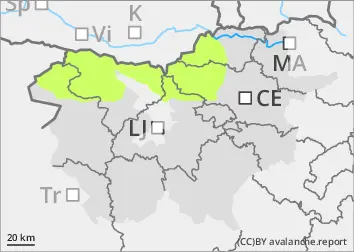
Danger level
 | 2000m |
|  |
|  |

![]()
The danger of avalanches is low.
The snowpack is mostly stable. In arid areas above the forest line, weak layers may be present in the snowpack. In a few places in the high alpine regions, a small, clustered Avalanche may be triggered under higher loads.
Snowpack
dp.4: cold following warm / warm following cold
There is little snow, with a crust on top. There is some new snow on the old snow base at altitudes of 2000 m. Peaks and ridges may be blown. On the Sunny slope, there are already significant areas of land outside High alpine regions. In the high alpine regions, weak layers may be present in the old snow cover.
Tendency
Snow conditions are not expected to change significantly in the coming days. The Crust will strengthen overnight and soften during the day on the Sunny slope. Sunday will be fairly clear in the mountains, remaining relatively warm for this time of year. Monday will see some more clouds, with light southerly winds. Temperatures will be around 0 °C at 1500 m and -3 °C at 2500 m.