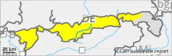
The avalanche danger is moderate. The snow that has fallen in the last few days is the main problem. Slab avalanches can be triggered in places on steep slopes at higher altitudes with low additional loads. On shady slopes at higher elevations, deeper layers can be disturbed and avalanches can reach medium size.
Wet snow becomes a problem below approx. 1800 m. On steep slopes interspersed with rocks, in very steep forest aisles and when exposed to sunlight, small, moist and wet loose snow avalanches are increasingly triggered spontaneously.
On very steep, smooth meadow slopes at all altitudes and exposures, smaller sliding snow avalanches can also detach themselves.
Snowpack
The snow that has fallen in the last few days is clearly settling in mild temperatures. At higher altitudes, there are weak intermediate layers in the upper half metre of the snow cover in places. Under older accumulations of drifting snow, soft, fragile snow layers have been preserved in places. Only here is a break propagation over larger areas possible. Up to around 1800 metres, the snow becomes moist and loses its firmness with the onset of precipitation, mild temperatures and sunshine during the course of the day. The ground is not frozen and the snowpack base is often wet.
Tendency
With the forecast cooling, the wet snow problem will ease again at the beginning of next week.
Danger level
1800m
Avalanche Problem
New snow
1800m
Wet snow
1500m
Pay attention to ground contact and risk of falling!
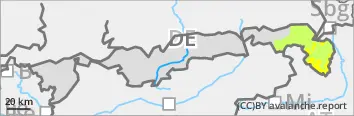
The avalanche danger is moderate above 1800 metres and low below. The snow that has fallen in the last few days is the main problem. Slab avalanches can be triggered in places on very steep slopes with little additional load. On shady slopes at high altitudes, lower-lying weak layers can be disturbed and avalanches can reach medium size.
Wet snow becomes a problem below approx. 1500 metres. Here, individual damp and wet loose snow avalanches spontaneously break loose in steep rocky terrain and in very steep forest aisles. Occasionally, the wet snow also comes off on the ground.
Snowpack
The snow that has fallen in the last few days is clearly settling in mild temperatures. At higher altitudes, there are weak intermediate layers in the upper half metre of the snow cover in places. Underneath older accumulations of drifting snow, soft layers of snow that are susceptible to disturbance remain in places. Up to 1500 metres, the snow becomes moist with the onset of precipitation and mild temperatures and loses its firmness. The ground is not frozen and the snowpack base is often wet.