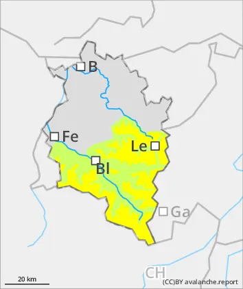
Beware: small snowdrifts at high altitude and daytime rise in avalanche danger.
Fresh snowfall and small fresh snowdrifts are increasingly prone to triggering with ascending altitude. Avalanche prone locations occur in ridgeline terrain and in wind-loaded gullies and bowls. Small triggerings are possible by winter sports enthusiasts, In isolated cases, small glide-snow avalanches are also possible. A cautious route selection is recommended. During the course of the day due to solar radiation and higher daytime temperatures, increasingly frequent moist slides and loose-snow avalanches are possible. Backcountry ski tours should be launched early and come to an end early in the day.
Snowpack
The old snowpack is thoroughly wet up to high altitudes. In ridgeline terrain in high-alpine zones, local small-area snowdrift accumulations are evident. In seldom-tracked terrain on shady steep slopes in high-alpine zones, there are unfavorable intermediate layers inside the snowpack. There have, however, been now avalanches reported over the last few days. Very little information from outlying terrain is available to the Avalanche Warning Service. Details of current weather conditions at the measurement stations of the LWD are available at https://lawis.at/station/
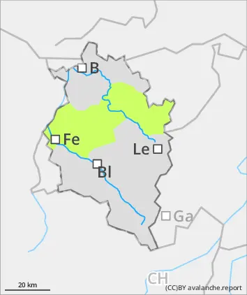
Tendency
Due to higher daytime temperatures and solar radiation, loose-snow slides and small wet-snow avalanches are possible during the course of the day
Danger level
Moist loose-snow slides due to higher daytime temperatures
Avalanche danger is low. The small amount of fresh snow fell on bare ground in many places. At high altitudes it is will bonded with the old snowpack. In isolated cases, small glide-snow avalanches are possible.
Snowpack
Small amounts of fresh snow lie deposited atop a thoroughly wet old snowpack surface. Bare ground at low and intermediate altitudes. All in all, a cohesive area-wide snowpack exists only above 1800m. Very little information from outlying terrain is available to the Avalanche Warning Service. For weather details, see: https://lawis.at/station/
Tendency
On Monday, intermittently sunny, milder. During the course of the day, showers are possible. Avalanche danger levels are not expected to change significantly.