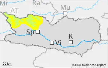
Avalanche prone locations along the Salzburg border
Danger of wet-snow avalanches exists already in the early morning. Due to rainfall below 2600m, isolated mostly small wet-snow avalanches are possible, esp. alng the Salzburg border. Due to fresh snow and moderate-velocity winds, trigger-sensitive snowdrift accumulations will be generated over the course of the day which can be triggered by one sole skier, but will be mostly small-sized releases. Caution urged in gullies and bowls and behind protruberances in the terrain along the Salzburg border.Danger zones occur above 2600m. Isolated danger zones occur also on sunny slopes in high-alpine zones.
Snowpack
dp.6: cold, loose snow and wind dp.10: springtime scenario
Above 2200m, 10cm of fresh snow was registered. During the night, up to 15cm of additional snowfall is anticipated above 2200m. Due to fresh snow and moderate-to-strong northerly winds, small snowdrift accumulations have been generated, they lie deposited on shady slopes near ridgelines above 2600m atop soft layers. Below 2600m: the old snowpack is wet. The surface can hardly freeze at night and rapidly softens in morning, esp. along the Salzburg border following a night of overcast skies. Below 2200m hardly any snow on the ground.
Tendency
Little change expected
Danger level
Avalanche Problem
Wet snow
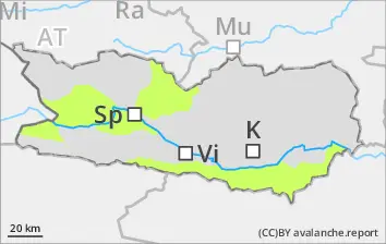
Isolated danger zones
Only isolated mostly small wet-snow avalanches are still possible during the course of the day. Caution urged in gulies in the major areas of precipitation. The runout zones should be give great attentiveness.
Snowpack
dp.10: springtime scenario
Weather conditions have led to the snowpack becoming thoroughly wet. Many starting zones have completely discharged.
Tendency
No significant change expected.
Danger level
Avalanche Problem
Wet snow
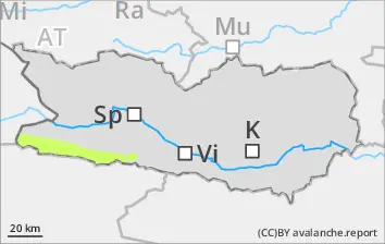
Beware wet snow
Wet-snow avalanches are small but can be triggered even by one sole skier in isolated cases, esp. at the foot of rock walls along the Italian border following nights of overcast skies. Especially in summit zones, isolated small wet loose-snowslides are possible. Due to rainfall, the likelihood of wet-snow avalanches triggering will increase somewhat. Many starting zones are already discharged completely.
Snowpack
dp.10: springtime scenario
Above 2200m, 10cm of fresh snow was registered, locally more. Weather conditions are making the snowpack even wetter, also the recent snowfall. The old snowpack is wet, esp. along the Italian border following nights of overcast skies. The surface can hardly freeze at night and rapidly softens in morning. Below 1800m hardly any snow on the ground.