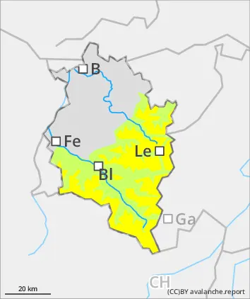
Slight increase in avalanche danger due to fresh snowfall
Avalanche danger will rise to modearte above 2200m due to fresh snowfall and wind. Small-area snowdrifts are increasingly prone to triggering with ascending altitude. Danger zones occur in ridgeline terrain and in wind-loaded gullies and bowls. In zones where there has been rain impact, small wet-snow avalanches are possible on steep slopes which have not yet discharged. In isolated cases, also small glide-snow avalanches are possible. Particularly in the Silvertta above 2600m, small to medium-siozed avalanches can be triggered by winter sports enthusiasts by large additional loading. Such danger zones lie in little-tracked, shady backcountry terrain and are difficult to recognize.
Snowpack
During mild nights of clear skies, the snowpack can freeze only slightly and in some places form a melt-freeze crust capable of bearing loads. At high altitudes, 10-25cm of fresh snow is anticipated. Due to intermittently moderate-strength westerly winds, small snowdrift accumulations will be generated afresh. In zones with rain impact, the already thoroughly wet snowpack will be weakened another notch. Particularly in the Silvretta at high altitudes on very steep shady slopes, unfavorable intermediate layers are evident inside the snowpack.
Tendency
On Friday, conditions will be variable, cool, with intermittent snowfall down to 1600m. Regionally, avalanche danger can increase somewhat at high altitudes.
Danger level
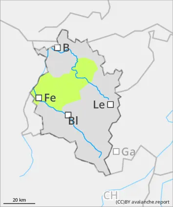
Caution: increasing danger in daytime cycle of avalanche danger
Avalanche danger will increase slightly above 1600m. The small amounts of fresh snow will often fall on ground which is bare of snow. At high altitudes, it consolidated well with the moist old snowpack surface. In regions with rain-impact, small wet-snow avalanches are possible on steep slopes in all aspects which have not yet discharged. In isolated cases, small glide-snow avalanches are possible.
Snowpack
During partially cloudy nighttime hours, reduced outgoing longwave radiation, the snowpack can freeze only superficially. With higher daytime temperatures and solar radiation the thin crust swiftly softens and the snowpack loses its firmness and weakens further.
Tendency
On Friday, conditions will be variable, cool, with intermittent snowfall down to 1600m. Regionally, avalanche danger can increase somewhat at high altitudes.