Avalanche danger is low. In isolated cases, small glide-snow or wet-snow avalanches can release in steep terrain which has not yet discharged or it can be triggered by persons.
Snowpack
On sunny slopes, the ground is becoming bare. What little snow there is, is moist-to-wet (0-degree isotherm) and often forms a crust capable of bearing loads after a night of clear skies. Daytime warming and solar radiation soften the crust and make it forfeit its firmness.
Tendency
Slight daytime danger cycle (wet-snow activity) within the same Danger Level
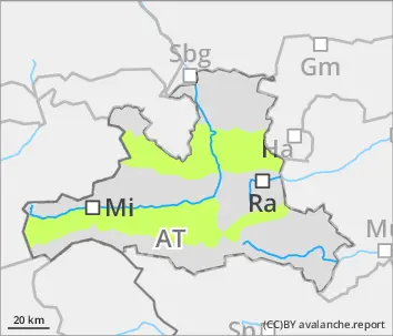
BEFORE NOON Danger level
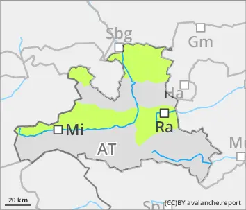
2800m
Avalanche Problem
Wet snow
2800m
Wind slab
2600m
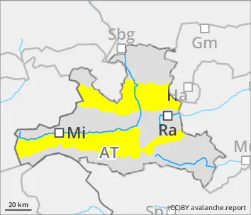
AFTERNOON Danger level
Avalanche Problem
Wet snow
Wind slab
2600m
Beware snowdrifts in high-alpine zones, wet-snow problem lower down
Avalanche danger is moderate, on steep slopes below 2800m which have not yet discharged, small-to-medium moist/wet-snow avalanches can releases spontaneously, esp. with extended sunshine windows, or be triggered by persons. Also isolated small-to-medium glide-snow avalanches are possible. Danger zones for small snowdrifts occur in shady wind-loaded gullies and bowls above 2800m. Dry-snow slab avalanches can be triggered here by one sole skier. Isolated avalanches can fracture down to the wet layers and sweep them along, thereby growing to medium size.
Snowpack
The snowpack is moist or wet up to high altitutudes, contains melt-freeze crusts even though the snowpack is quite compact overall, weak layers are isolated but occur above 2500m. In high-alpine zones, 20cm of fresh fallen snow (Venediger Massif) lie deposited atop the wind-impacted snowpack. Southerly winds have formed snowdrift accumulations there, often deposited atop faceted expansively metamorphosed crystals and prone to triggering in places. Higher daytime temperatures and solar raditaion moisten the snowpack and cause firmness to be forfeited.
Tendency
Springtime situation: slight daytime danger cycle. The snowdrift problem is receding.
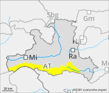
BEFORE NOON Danger level
2200m
Avalanche Problem
Wet snow
2200m
AFTERNOON Danger level
Avalanche Problem
Wet snow
Hardly any cold reserves following a cloudy night
Avalanche danger is moderate. In a few places on steep slopes which have not yet discharged, small-to-medium moist/wet avalanches can trigger naturally, esp. when windows of sunshine are more extended, or be triggered by winter sports enthusiasts. In isolated cases, small-to-medium glide-snow avalanches are possible.
Snowpack
The snowpack is moist or wet up to high altitudes, contains melt-freeze crusts even though the snowpack is quite compact overall, weak layers are isolated but occur above 2500m. In high-alpine zones, a few cm of fresh snow lie deposited atop the wind-impacted snowpack, bonding to the base is good, only in highest regions (above 2600m) on shady slopes are there layers of faceted expansively metamorphosed crystals which constitute a weak layer. Higher daytime temperatures and solar raditaion moisten the snowpack and cause firmness to be forfeited.
Tendency
No significant change expected. High clouds on Sunday can hamper the radiation.
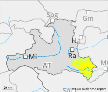
BEFORE NOON Danger level
Avalanche Problem
Wet snow
Wind slab
2600m
AFTERNOON Danger level
Avalanche Problem
Wet snow
Wind slab
2600m
Isolated medium-sized wet-snow and glide-snow avalanches
Avalanche danger is initially low, then rises to moderate. In a few places on steep slopes below 2800m, small-to-medium moist/wet avalanches can trigger naturally, or be triggered by winter sports enthusiasts. In isolated cases, small-to-medium glide-snow avalanches are possible. In the Hohe Tauern above 2800m in wind loaded shady terrain, in shady gullies and bowls, dry-snow slab avalanches can be triggered by minimum additional loading. In isolated cases avalanches can fracture down to deeper layers and then grow to medium size.
Snowpack
The still evident snowpack below 2000m has turned to summer-firn snow. Even above that altitude the snow is moist or wet, contains melt-freeze crusts, though the overall somepack is quite compact. In places, there are a few cm of fresh snow deposited atop this old snowpack surface. In high-alpine zones, storm-strength southerly foehn winds have transported the snow in places. In shady aspects above 2800m, faceted expansively metamorphosed old snow constitutes a potential weak layer. Higher daytime temperatures and solar radiation moisten the snowpack and cause it to lose its firmness.
Tendency
Springtime situation: slight daytime danger cycle due to wet-snow avalanche activity. Snowdrift problem receding.