Only few danger zones for slab avalanches in old snow
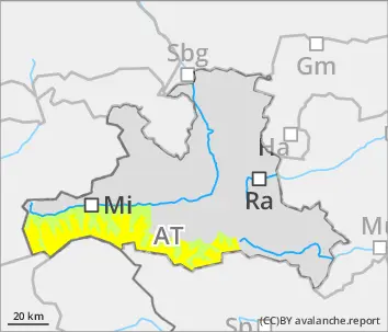
Avalanche danger above 2400m is moderate. Slab avalanches can be triggered by minimum additional loading in some places, caution urged in transitions from shallow to deeper snow. On very steep north-facing slopes above 2400m and on W/E-facing slopes above 2600m, avalanches can fracture down to more deeply embedded layers of the snowpack and in isolated cases grow to large size. On extremely steep sunny slopes, small moist loose-snow avalanches can trigger naturally during the course of the day. Due to strong-velocity northerly winds, small danger zones will be generated through fresh snowdrift patches which can be prone to triggering on very steep north-facing slopes (most are easy to recognize). From very steep grass-covered slopes below 2600m, isolated small-to-medium glide-snow avalanches can trigger naturally.
Snowpack
The melt-freeze encrusted snowpack gradually softens up during the early daytime hours. In extended north-facing terrain there are still weak layers of faceted crystals in the old snowpack. On shady summit slopes, shallow snowdrift patches lie deposited often atop weak layers of surface hoar or faceted crystals. In high-alpine regions, thin snowdrifts are being generated on E/S-facing slopes. On shady slopes below 2200m and on sunny slopes, the old snowpack is mostly moist. On very steep, little structure terrain surfaces, the entire snowpack oftens glides downhill.
Tendency
On Saturday, sunny and warmer, zero-degree level at 3000m. Air will be moister, winds will taper off - naturally triggered wet-snow and glide-snow avalanches will increase.
Danger level
2600m
Avalanche Problem
Gliding snow
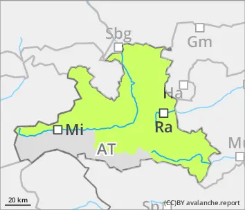
2600m
Mostly favorable avalanche situation
Avalanche danger is low. During the course of the day, likelihood of small wet-snow avalanches triggering on sunny steep slopes will increase somewhat. On very steep grass-covered slopes below 2600m which have not yet discharged, isolated mostly small glide-snow avalanches can trigger naturally. Isolated danger zones for slab avalanches occur on very steep shady slopes above 2400m. Danger zones occur in wind-loaded gullies and bowls, behind protruberances in the terrain and in ridgeline areas, as well as in transitions from shallow to deeper snow.
Snowpack
The melt-freeze encrusted snowpack, only sometimes capable of bearing loads, gradually softens up during the early daytime hours. In extended north-facing terrain there are still weak layers of faceted crystals in the old snowpack. On shady summit slopes, shallow snowdrift patches lie deposited often atop weak layers of surface hoar or faceted crystals. In high-alpine regions, thin snowdrifts are being generated on E/S-facing slopes. On shady slopes below 2200m and on sunny slopes, the old snowpack is mostly moist. On very steep, little structure terrain surfaces, the entire snowpack oftens glides downhill.
Tendency
On Saturday, sunny and warmer, zero-degree level at 3000m. Air will be moister, winds will taper off - naturally triggered wet-snow and glide-snow avalanches will increase.