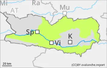
Weak layers in the uppermost part of the snowpack can in isolated cases be triggered by one sole skier. Such danger zones occur esp. on steep N/W/E-facing slopes above 2100m. Avalanches can in isolated cases grow to medium size. Due to solar radiation and daytime warmth, increasingly frequent wet-snow avalanches can be expected, especially on extremely steep sunny slopes, releases mostly small-sized. Acute danger of falling on hardened snowpack surfaces in steep terrain.
Snowpack
dp.1: deep persistent weak layer dp.10: springtime scenario
Clear skies are expected over far-reaching areas. The snowpack surface will freeze and be capable of bearing loads in early morning, softening subsequently over the course of the day. The old snowpack is moist, particularly on sunny slopes at all altitudes and on shady slopes below 2100m. Inside the old snowpack on N/W/E-facing slopes there are faceted, expansively metamorphosed weak layers, esp. abov 2400m. Below 1800m there is hardly any snow on the ground.
Tendency
Little change in avalanche danger levels anticipated
Danger level
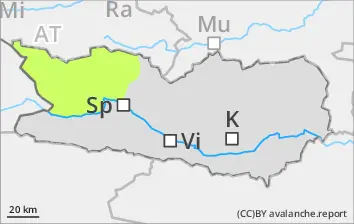
Favorable avalanche situation
Quite favorable avalanche conditions prevail in general. Due to solar radiation, isolated moist avalanches can be expected during the course of the day, esp. on extremely steep sunny slopes. On hardened surfaces, acute danger of falls.
Snowpack
dp.10: springtime scenario
Snowpack will consolidate as temperatures drop, a surface crust will form. The old snowpack is moist, esp. on sunny slopes at all altitudes and on shady slopes below 2100m. Below 1600m there is hardly any snow on the ground.
Tendency
Little change in avalanche danger levels anticipated
Danger level
2100m
Avalanche Problem
Persistent weak layer
2100m
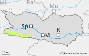
Isolated danger zones at high altitudes
Weak layers in the uppermost part of the snowpack can in isolated cases be triggered by one sole skier. Such danger zones occur esp. on steep N/W/E-facing slopes above 2100m. Avalanches can in isolated cases grow to medium size. Due to solar radiation and daytime warmth, increasingly frequent wet-snow avalanches can be expected, especially on extremely steep sunny slopes, releases mostly small-sized. Acute danger of falling on hardened snowpack surfaces in steep terrain.
Snowpack
dp.1: deep persistent weak layer dp.10: springtime scenario
Clear skies are expected over far-reaching areas. The snowpack surface will freeze and be capable of bearing loads in early morning, softening subsequently over the course of the day. The old snowpack is moist, particularly on sunny slopes at all altitudes and on shady slopes below 2100m. Inside the old snowpack on N/W/E-facing slopes there are faceted, expansively metamorphosed weak layers, esp. abov 2400m. Below 1500m there is hardly any snow on the ground.
Tendency
Little change in avalanche danger levels anticipated