Avalanches can be triggered in the old snow even by one sole skier. In addition, avalanches can be triggered even by minimum additional loading in the near-surface layers of the snowpack, esp above 2000m. Avalanches can on shady slopes sweep along the moist layers of the old snowpack and grow to large size. Caution urged at the foot of rock walls and behind protruberances in the terrain, and in gullies and bowls. Due to moistening, increasingly frequent moist loose-snow avalanches can be expected, also medium-sized ones, esp. after a night of cloudy skies on extremely steep slopes. Caution also urged towards moist slides and avalanches, also medium sized releases on extremely steep slopes after a night of cloudy skies. The runout zones should be circumvented. On very steep grass-covered slopes glide-snow avalanches are possible, also medium sized releases.
Snowpack
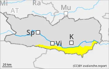
dp.7: snow-poor zones in snow-rich surrounding dp.6: cold, loose snow and wind
Since Friday, 50-90cm of fresh snow has been registered above 1600m, locally more. High air moisture has moistened the snowpack esp. above 2400m. Heavily clouded skies mean the snowpack cannot firm up during the nocturnal hours. More deeply embedded inside the snowpack on shady slopes are faceted, expansively metamorphosed weak layers, esp. above 2000m. Fresh snowdrift accumulations have been deposited atop soft layers esp. above 2400m.
Tendency
Weather conditions will lead to a gradual stabilization of the snowpack
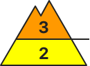
Danger level
Avalanche Problem
Wet snow
Persistent weak layer
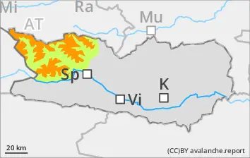
2000m
Caution: snowdrift accumulations
With lower temperatures, isolated small-to-medium moist slides and avalanches are possible at all altitudes, esp. on extremely steep slopes following a night of cloud skies. Avaalanches can be triggered in the old snow even by one sole skier, esp. on shady slopes above 2000m. Avalanches can fracture down to the moist snowpack layers, which pushes the runout zones of avalanches further downhill. Avalanches can reach medium size.
Snowpack
dp.1: deep persistent weak layer dp.10: springtime scenario
Since Friday, 20-30cm of fresh snow has been registered above 1800m, locally more. High air moisture has moistened the snowpack esp. above 2400m. Heavily clouded skies mean the snowpack cannot firm up during the nocturnal hours. More deeply embedded inside the snowpack on shady slopes are faceted, expansively metamorphosed weak layers, esp. above 2000m. Fresh snowdrift accumulations have been deposited atop soft layers esp. above 2000m.
Tendency
Low temperatures and low air moisture will lead to a gradual stabilization of the snowpack
Danger level
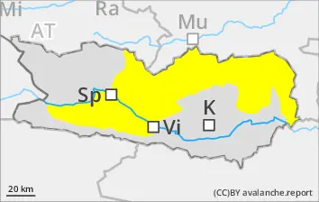
2000m
Avalanche Problem
Persistent weak layer
2000m
Wind slab
2400m
Gliding snow
2400m
Caution: weak layers in the old snow
Avalanches can be triggered in the weak old snow even by one sole skier, esp. on shady slopes above 2000m. They can fracture down to the moist layers of the old snowpack, which pushes the runout zones further downhill. Most releases are medium-sized. Whumpf noises and glide cracks when you tread on the snowpack are indicators of imminent danger. Fresh snowdrifts can be triggered by one sole skier esp. on shady slopes above 2400m. Caution urged at the foot of rock walls, behind protruberances, and in gullies and bowls. Activity of small-to-medium loose-snow avalanches will increase significantly. Runout zones should be circumvented. On very steep grass-covered slopes, glide-snow avalanches are possible, also medium sized releases.
Snowpack
dp.1: deep persistent weak layer dp.7: snow-poor zones in snow-rich surrounding
Since Friday, 25-50cm of fresh snow has been registered above 2000m, locally more. High air moisture has moistened the snowpack esp. above 2400m. Heavily clouded skies mean the snowpack cannot firm up during the nocturnal hours. More deeply embedded inside the snowpack on shady slopes are faceted, expansively metamorphosed weak layers, esp. above 2000m. The snowpack is moist up to intermediate altitudes. Nocturnal outgoing longwave radiation is nearly absent.
Tendency
Caution: weak layers in the old snow
Danger level
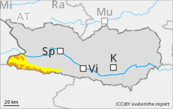
1900m
Avalanche Problem
Persistent weak layer
1900m
Wet snow
Gliding snow
Small to medium sized moist slides and avalanches possible
With lower temperatures, isolated small-to-medium moist slides and avalanches are possible at all altitudes, esp. on extremely steep slopes following a night of cloud skies. Avalanches can be triggered in the weak old snow even by one sole skier, esp. on shady slopes above 2000m. They can fracture down to the moist layers of the old snowpack, which pushes the runout zones further downhill. Most releases are medium-sized. Whumpf noises and glide cracks when you tread on the snowpack are indicators of imminent danger. Fresh snowdrifts can be triggered by one sole skier esp. on shady slopes above 2400m. Caution urged at the foot of rock walls, behind protruberances, and in gullies and bowls. Activity of small-to-medium loose-snow avalanches will increase significantly. Runout zones should be circumvented. On very steep grass-covered slopes, glide-snow avalanches are possible, also medium sized releases.
Snowpack
dp.1: deep persistent weak layer dp.10: springtime scenario
Since Friday, 50-100cm of fresh snow has been registered above 1600m, locally more. High air moisture has moistened the snowpack esp. above 2400m. Heavily clouded skies mean the snowpack cannot firm up during the nocturnal hours. More deeply embedded inside the snowpack on shady slopes are faceted, expansively metamorphosed weak layers, esp. above 1900m.
Tendency
Due to lower temperatures and low air moisture the snowpack is consolidating