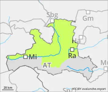
Danger level
 | 1900m |
|  |
|  |

![]()
Danger zones blanketed by fresh snow on north-facing slopes
Avalanche danger is moderate above 1900m, below that altitude danger is low. Small slab avalanches can be triggered by one sole skier in a few steep spots. The difficult-to-recognize (blanketed) danger zones lie on NW/N/E facing slopes, often distant from ridgelines. Caution urged esp. at entry points into very steep gullies and bowls. During the course of the day, naturally triggered loose-snow avalanches can be expected in extremely steep south-facing terrain. On steep grass-covered slopes, isolated small glide-snow avalanches are possible in isolated cases.
Snowpack
Up to 10cm of fresh, cold snow (locally up to 20cm) is expected without much wind influence. On Thursday, southerl foehn winds will generate small-area snowdrifts on north-facing slopes which will be deposited atop weak layers, esp. on shady slopes. The below-average old snowpack is expansively metamorphosed at high and high-alpine altitudes, but hardly tends towards fracture propagation. On sunny slopes, melting forms dominate in the old snowpack.
Tendency
Also over the weekend, snowfall anticipated. In places, moderate-velocity southerly winds can generate new snowdrifts.