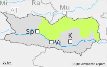
Isolated danger zones on wind-loaded slopes above 2000m
Due to fresh snow and moderate-velocity southerly winds, trigger-sensitive snowdrift accumulations have been generated esp. on NW/N/NE facing slopes, shallow and triggerable only in isolated cases. Wet loose-snow avalanches are hardly still possible. Most starting zones have already discharged.
Snowpack
Rainfall made the snowpack wet widespread. Nocturnal outgoing longwave radiation is very good in places. Sunshine and daytime warmth will soften the snowpack during the course of the day.
Tendency
Regional rise in avalanche danger
Danger level
2400m
Avalanche Problem
Wind slab
2400m
Beware snowdrifts
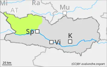
Due to fresh snow and moderate-velocity southerly winds, trigger-sensitive snowdrift accumulations have been generated esp. in ridgeline terrain, in gullies and bowls, esp. above 2400m. Avalanches can be triggered by persons in the uppermost layers. In addition, isolated avalanches can fracture down to deeper layers of the snowpack and then grow to medium size. In starting zones which have not yet discharged, mostly small wet loose snow avalanches are possible, and can be triggered by winter sports enthusiasts. Caution urged in extremely steep slopes below 2000m. In addition, in the major areas of precipitation, isolated mostly small glide-snow avalanches are possible.
Snowpack
About 2-5 cm of fresh snow was registered above 2000m, locally more. Rainfall made the snowpack wet widespread. Nocturnal outgoing longwave radiation is very limited. Winds have transported the fresh snow, also some of the old snow. Fresh snow and drifts lie deposited on shady slopes above 2000m atop an unfavorable old snowpack surface. In the lowermost part of the snowpack on shady slopes there are faceted weak layers evident.
Tendency
Increasing avalanche danger
Danger level
2000m
Avalanche Problem
Persistent weak layer
2000m
Wet snow
2000m
Fresh snowdrift accumulations lie deposited atop unfavorable old snowpack surfaces. Danger zones often blanketed over.
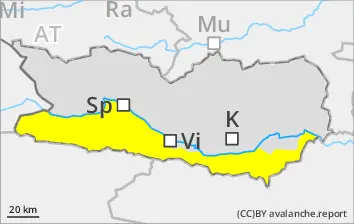
Due to fresh snow and moderate-velocity southerly winds, trigger-sensitive snowdrift accumulations have been generated esp. in ridgeline terrain, in gullies and bowls, esp. above 2000m along the Italian border in the regions where snowfall has been heaviest. Avalanches can be triggered by persons in the uppermost layers. In addition, isolated avalanches can fracture down to deeper layers of the snowpack and then grow to medium size. In starting zones which have not yet discharged, mostly small wet loose snow avalanches are possible, and can be triggered by winter sports enthusiasts. Caution urged in extremely steep slopes below 2000m. In addition, in the major areas of precipitation, isolated mostly small glide-snow avalanches are possible.
Snowpack
dp.6: cold, loose snow and wind dp.1: deep persistent weak layer
Particularly along the Italian border, about 15-20 cm of fresh snow was registered above 2000m, locally more. Rainfall made the snowpack wet widespread. Nocturnal outgoing longwave radiation is very limited. Winds have transported the fresh snow, also some of the old snow. Fresh snow and drifts lie deposited on shady slopes above 2000m atop an unfavorable old snowpack surface. In the lowermost part of the snowpack on shady slopes there are faceted weak layers evident.