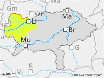
Avalanche danger above the treeline to moderate. Danger spots are located in very steep entries, gullies and behind ridgelines in the expositions north to east. There slab avalanches can be triggered by small additional loads.
Snowpack
In higher altitudes a fresh snowdrift cover accumulates north and east on top of a snow surface which is weakened by kinetic metamorphosis. This weak layer can be disturbed. Otherwise the new snow bonds very good with the old snow cover only in some places the bonded layers with different hardness can be prone to triggering. Weak layers within the snow base (kinetic metamorphosis) can hardly be triggered. Blow-off areas are often hard and icy.
Tendency
On Friday it will be predominately cloudy and the summits are foggy. Snowline will be around 900 m. No significant change of the avalanche danger.
Danger level
Avalanche Problem
Wind slab
During the course of the day fresh danger spots in some places.
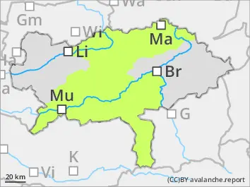
Low avalanche danger. Nevertheless fresh snowdrift deposits in some places in shady steep areas which can be triggered by small additional loads. Danger of falling is higher than the danger of being buried
Snowpack
Partially a thin snowdrift layer is forming in higher shady areas on top of a layer wich kinetic metamorphosed. This weak layer can be prone to triggering. Otherwise the new snow is sufficiently bonding with the old snow cover. The snow base is predominantly stable. Blow-off areas are often hard and icy.
Tendency
Wednesday night precipitation is called throughout whole Styria. In the morning of Thursday the precipitation is clearing up in direction east and Fischbacher Alps. Snowline is 1.000 m. The afternoon will stay dry in the east and partially sunny. In the Dachstein and Schladming region snowfall is possible. North to northwesterly moderate winds. Temperatures at noon are around -4degrees in 2.000 m.