Danger level
 | 1800m |
|  |
|  | ||||
| |
|  |


![]()
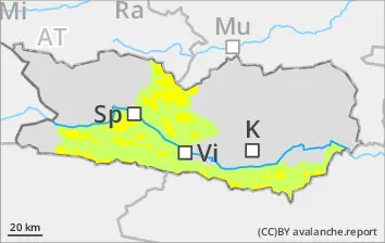
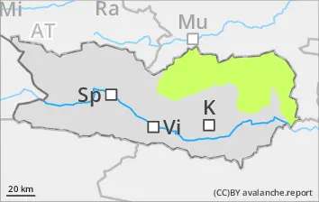
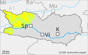
Caution: freshly generated snowdrift accumulations. Avalanche danger at upper part of Level 2 (Moderate) in regions with lots of wind
Due to fresh snow and moderate northerly winds, often trigger-sensitive snowdrift accumulations have been generated in ridgeline terrain, gullies and bowls. These drifts can be triggered in many cases by one sole skier in all aspects above 1800m. Danger zones are easily recognized to the practiced eye. In morning, likelihood of triggering increases somewhat. Due to solar radiation, increasingly frequent small loose-snow avalanches can be expected, esp. on steep rocky slopes. The runout zones require adequate consideration. In addition, isolated avalanches can trigger in the weak old snow, esp. on W/N/E facing slopes above 2200m. Caution urged in transitions from shallow to deep snow, e.g. at entry points into gullies and bowls. Caution in transitions from shallow to deeper snow, e.g. at entry points into gullies and bowls. Avalanches can reach medium size.
Snowpack
dp.6: cold, loose snow and wind
dp.4: cold following warm / warm following cold
Fresh snow (10-20cm) was registered widespread. Strong velocity winds transported the fresh snow, fresh drifts accumulated at high and high-alpine altitudes and were deposited on top of an unfavorable old snowpack surface. In the lower part of the snow cover, particularly on W/N/E facing slopes, there are faceted, expansively metamorphosed weak layers evident. As of midday, solar radiation will lead to a moistening of the snowpack on very steep sunny slopes below 2800m.
Tendency
Fresh snowdrifts need to be cautiously assessed. Pay attention to weak layers in old snowpack.