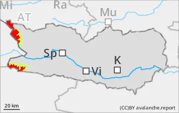
Enduring precipitation: medium and in isolated cases large-sized naturally triggered avalanches are possible in high-altitude starting zones, esp. during the course of the night in the major areas of precipitation. One sole skier can easily trigger avalanches. Remote triggerings are possible, esp. on shady wind-protected slopes where the fresh snowfall has been heavy. Especially treacherous are the foot of rock walls. Avalanches can in isolated cases sweep along the wet snowpack, which extends the plummet path of the releases. In addition, in the major areas of precipitation, mostly small glide-snow avalanches are possible. As a result of solar radiation, increaslingly frequent mostly small loose-snow avalanches can be expected. A great deal of experience is imperative in the assessment of avalanche danger.
Snowpack
dp.6: cold, loose snow and wind dp.1: deep persistent weak layer
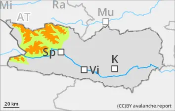
Above 1800m, 50-60cm of snow was registered, locally more. During the night above 1000m, 10-20 cm of snowfall is still expected. The strong-velocity winds have intensively transported the snow. In the uppermost part of the snowpack, particularly on shady wind-protected slopes, there are soft weak layers. Shady, wind-protected zones above 2400m: lots of fresh snowfall and drifts are being deposited atop unfavorable old snowpack surfaces. Shady slopes where the snow is shallow above 1800m: fresh snow and drifts are being deposited atop a weak old snowpack. Sunny slopes above 2400m: fresh snow and drifts are being deposited atop crusts. Extremely steep grass-covered slopes below 2400m: weather conditions are generally increasing the dange rof glide-snow avalanches. Shady slopes below 1800m: the fresh snow lies deposited atop a thoroughly wet old snowpack.
Tendency
Naturally triggered activity of slab avalanches will decrease
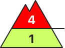
Danger level
1800m
Avalanche Problem
Persistent weak layer
1800m
Gliding snow
2000m
Significant rise in avalanche danger as snowfall intensifies
Danger level 4 - “high” - will be reached above 1800m starting at midday. Due to intensive snowfall, increasingly frequent naturally triggered avalanches can be expected during the course of the day, also large-sized releaes, even by minimum additional loading. Remote triggerings are possible, particularly on steep wind-protected slopes where there has been lots of fresh snow. Also treacherous: the foot of rock walls. On extremely steep stopes, mostly small loose-snow avalanches can be expected. In isolated cases the thoroughly wet snowpack can be swept along, which lengthens the plummet zone of the release. In addition, during the afternoon in the major areas of precipitation, mostly small-sized glide-snow avalanches can release in isolated cases. Exposed sectors of transportation route can be endanged from place to place. A great deal of experience in the assessment of avalanche dangers is imperative.
Snowpack
dp.6: cold, loose snow and wind dp.3: rain
Above 1800m, 50-120cm of fresh snow was registered, locally more. During the nighttime hours, above 1200m, another 15-30 cm of fresh snow is expected. Strong winds have intensively transported the fresh fallen snow. In the upper part of the snowpack esp. on shady wind-protected slopes there are weak soft layers evident. Shady wind-protected zones above 1800m: lots of fresh snow and drifts lie atop an unfavorable old snowpack surface. Shallow-snow shady slopes above 1800m: fresh snow and drifts will be deposited atop a weak old snowpack. Sunny slopes above 2200m: fresh snow and drifts lie atop a crust. Shady slopes below 1800m: the fresh snow lies atop a thoroughly wet old snowpack.
Tendency
Naturally triggered slab avalanches will decrease when the intensive snowfall comes to an end
Danger level
1800m
Avalanche Problem
Persistent weak layer
1800m
Gliding snow
2400m
New snow
1800m
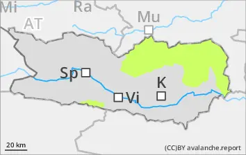
Dangerous avalanche situation at high altitudes due to fresh snowfall and winds
Avalanche danger lies in the upper zone of Danger Level 3, “considerable.” Avalanches can be triggered widespread by one sole skier and in isolated cases grow to large size. Remote triggerings are possible, esp. on shady wind-protected slopes in zones where snowfall has been heavy. Particularly treacherous are the bottom of rock walls. As a result of solar radiation, increasingly frequent, mostly small-sized loose-snow avalanches can be expected. In addition, in the major areas of precipitation, mostly small glide-snow avalanches are possible. Winter sports should limit themselves to secured zones.
Snowpack
dp.6: cold, loose snow and wind dp.1: deep persistent weak layer
Above 1800m, 50-60cm of snow was registered, locally more. During the night above 1000m, 10-20 cm of snowfall is still expected. The strong-velocity winds have intensively transported the snow. In the uppermost part of the snowpack, particularly on shady wind-protected slopes, there are soft weak layers. Shady, wind-protected zones above 2400m: lots of fresh snowfall and drifts are being deposited atop unfavorable old snowpack surfaces. Shady slopes where the snow is shallow above 1800m: fresh snow and drifts are being deposited atop a weak old snowpack. Sunny slopes above 2400m: fresh snow and drifts are being deposited atop crusts. Extremely steep grass-covered slopes below 2400m: weather conditions are generally increasing the dange rof glide-snow avalanches. Shady slopes below 1800m: the fresh snow lies deposited atop a thoroughly wet old snowpack.
Tendency
Naturally triggered slab avalanches will decrease when the intensive snowfall comes to an end
Danger level
1800m
Avalanche Problem
Persistent weak layer
1800m
Significant rise in avalanche danger as snowfall intensifies
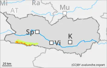
Due to fresh snowfall and strong-velocity SW winds, widespread snowdrift accumulations will be generated during the course of the day esp. in ridgeline terrain, in gullies and bowls. These can be easily triggered in all aspects, or else trigger naturally. Avalanches will be mostly medium-sized. We advise against winter sports in steep terrain.
Snowpack
dp.6: cold, loose snow and wind
Above 1800m, 50cm of fresh snow was registered, locally more. During the nighttime hours, above 1000m, another 10-20 cm of fresh snow is expected. Strong winds have intensively transported the fresh fallen snow. In the upper part of the snowpack esp. on shady wind-protected slopes there are weak soft layers evident. Shallow-snow shady slopes above 1800m: fresh snow and drifts will be deposited atop a weak old snowpack.
Tendency
Naturally triggered slab avalanches will decrease when the intensive snowfall comes to an end
Danger level
Avalanche Problem
Wet snow
Avalanches are hardly possible
As precipitation eases off, avalanches are hardly possible
Snowpack
dp.3: rain
Rainfall led to the snowpack becoming massively wet in all aspected over widespread areas. There is little snow on the ground.
Tendency
Decrease in danger of wet-snow avalanches as precipitation slackens off
Danger level
Avalanche Problem
Wet snow
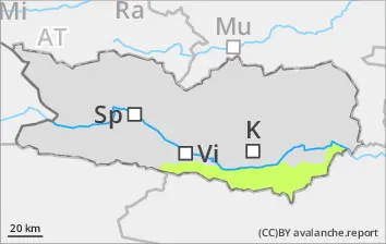
Decrease in danger of wet-snow avalanches as precipitation ends
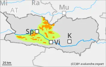
From starting zones which have not yet discharged, isolated wet-snow avalanches are possible, mostly small-sized, esp. along the Slovenian border. The wet-snow avalanches can from steel gullies plummet down into green zones in the major areas of precipitation.
Snowpack
dp.3: rain
Rainfall led to the snowpack becoming massively wet in all aspects
Tendency
Decreasing danger of wet-snow avalanches as precipitation slackens off