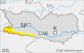
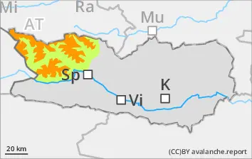
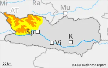
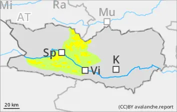
Significant rise in avalanche danger as snowfall intensifies
Danger level 4 - “high” - will be reached above 1800m starting at midday. Due to intensive snowfall, increasingly frequent naturally triggered avalanches can be expected during the course of the day, also large-sized releaes, even by minimum additional loading. Remote triggerings are possible, particularly on steep wind-protected slopes where there has been lots of fresh snow. Also treacherous: the foot of rock walls. On extremely steep stopes, mostly small loose-snow avalanches can be expected. In isolated cases the thoroughly wet snowpack can be swept along, which lengthens the plummet zone of the release. In addition, during the afternoon in the major areas of precipitation, mostly small-sized glide-snow avalanches can release in isolated cases. Exposed sectors of transportation route can be endanged from place to place. A great deal of experience in the assessment of avalanche dangers is imperative.
Snowpack
dp.6: cold, loose snow and wind dp.3: rain
Above 1800m, 50-120cm of fresh snow is anticipated, localy more. The strong-velocity winds will transport the fresh snow intensively. On shady wind-protected slopes above 1800m: lots of fresh snow and drifts will be deposited atop an unfavorable old snowpack surface. Shady slopes where the snow is shallow above 1800m: fresh snow and drifts will be deposited atop a weak old snowpack surface. Sunny slopes above 2200m: fresh snow and drifts will be deposited atop a crust. Extremely steep grass-covered slopes below 2000m: weather conditions are bringing about a generaly increase in danger of glide-snow avalanches.
Tendency
Naturally triggered slab avalanches will decrease when the intensive snowfall comes to an end
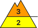
BEFORE NOON Danger level
Avalanche Problem
Wet snow
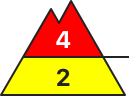
AFTERNOON Danger level
Avalanche Problem
Wet snow
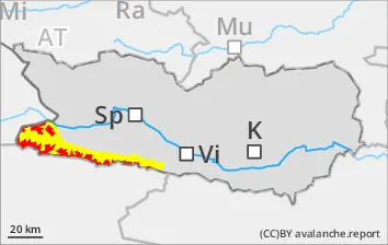
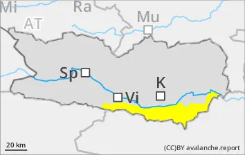
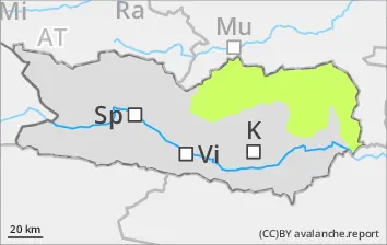
With rainfall up to 1900m, an unfavorable avalanche situation is taking shape
Due to intensive rainfall, many wet-snow avalanches can be expected during the course of the day, including medium-sized releases, particularly along the Slovenian border. The wet-snow avalanches can in steep gullies and bowls plummet down into green zones in the areas where precipitation is heaviest. It is advised to NOT partake in winter sports in steep terrain.
Snowpack
dp.3: rain
Rainfall during the course of the day will lead to the snowpack massively becoming thoroughly wet in all aspects
Tendency
Decreasing danger of wet-snow avalanches as precipiation slackens off
BEFORE NOON Danger level
1800m
Avalanche Problem
Persistent weak layer
1800m
AFTERNOON Danger level
1800m
Avalanche Problem
Persistent weak layer
1800m
Gliding snow
2400m
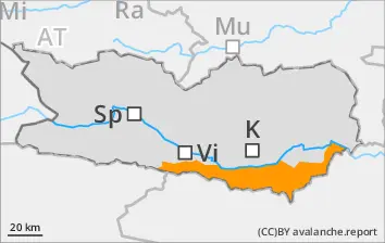
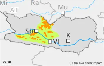
Significant rise in avalanche danger due to intensive snowfall
Due to intensive snowfall, increasingly frequent naturally triggered avalanches can be expected during the course of the day, also large sized releases, even by minimum additional loading, also remote triggerings, particularly on shady wind-protected slopes where there has been lots of fresh snow. Also treacherous: the foot of rock walls. In addition, during the afternoon in the major areas of precipitation, mostly small-sized glide-snow avalanches can release in isolated cases. Exposed sectors of transportation routes can be endanged from place to place. A great deal of experience in the assessment of avalanche dangers is imperative.
Snowpack
dp.6: cold, loose snow and wind
Above 1600m, 50-80cm of fresh snow is anticipated, localy more. On shady wind-protected slopes above 2400m: lots of fresh snow and drifts will be deposited atop an unfavorable old snowpack surface. Shady slopes where the snow is shallow above 1800m: fresh snow and drifts will be deposited atop a weak old snowpack surface. Sunny slopes above 2400m: fresh snow and drifts will be deposited atop a crust. Extremely steep grass-covered slopes below 2400m: weather conditions are bringing about a generaly increase in danger of glide-snow avalanches.
Tendency
Naturally triggered slab avalanches will decrease when the intensive snowfall comes to an end
BEFORE NOON Danger level
1800m
Avalanche Problem
Wind slab
1800m
AFTERNOON Danger level
1800m
Avalanche Problem
Wind slab
1800m
Significant rise in avalanche danger as snowfall intensifies
Due to fresh snowfall and strong-velocity SW winds, widespread snowdrift accumulations will be generated during the course of the day esp. in ridgeline terrain, in gullies and bowls. These can be easily triggered in all aspects, or else trigger naturally. Avalanches will be mostly medium-sized. We advise against winter sports in steep terrain.
Snowpack
dp.6: cold, loose snow and wind
Above 1800m, 50cm of fresh snow is anticipated, localy more. Shady slopes where the snow is shallow above 1800m: fresh snow and drifts will be deposited atop a weak old snowpack surface. Sunny slopes above 2200m: fresh snow and drifts will be deposited atop a crust. Extremely steep grass-covered slopes below 2000m: weather conditions are bringing about a generaly increase in danger of glide-snow avalanches.
Tendency
Naturally triggered slab avalanches will decrease when the intensive snowfall comes to an end
Danger level
Avalanche Problem
Wet snow
Due to rainfall, isolated wet loose-snow avalanches are possible during the course of the day
Due to rainfall, isolated wet loose-snow avalanches are possible during the course of the day, mostly small releases esp. in gullies and bowls in the major areas of precipitation.
Snowpack
dp.3: rain
During the course of the day rainfall will lead widespread to the snowpack massively becoming thoroughly wet. Very little snow lies on the ground.
Tendency
Decrease in danger of wet-snow avalanches as precipitation slackens off