Avalanche danger is low. Due to higher temperatures and solar radiation, small loose-snow slides can release naturally during the course of the day.
Snowpack
Due to rising temperatures, the snowpack has receded and is moistened at surface level up to intermediate altitudes, or else utterly wet. Overnight a melt-freeze crust can form which will then soften up during the daytime. The snowpack evidences currently no marked weak layers. There is, all in all, little snow on the ground.
Tendency
Increasing avalanche danger levels expected due to fresh snow and wind impact.
Danger level
Avalanche Problem
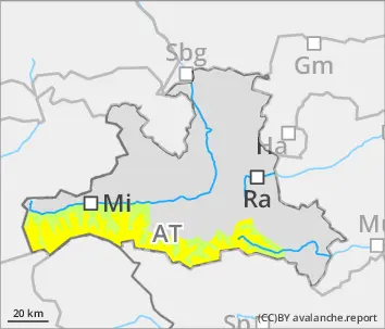
Wet snow
Loose-snow slides during the daytime in extremely steep terrain
Avalanche danger is low. Due to higher temperatures and solar radiation, small loose-snow avalanches can trigger naturally in extremely steep terrain (>40°). Also small glide-snow avalanches are possible at any time of day or night in all aspects.
Snowpack
Due to rising temperatures, the snowpack has receded and is moistened at surface level up to intermediate altitudes, or else utterly wet. Overnight a melt-freeze crust can form which will then soften up during the daytime. The snowpack evidences currently no marked weak layers. On grass-covered slopes or rocky plates the entire snowpack could begin to glide away. At high altitudes the near-surface loose-snow layers are often blanketed.
Tendency
Increasing avalanche danger levels (snowdrift problem) expected due to fresh snow and wind impact.
Danger level
2400m
Avalanche Problem
Persistent weak layer
2400m
Wet snow
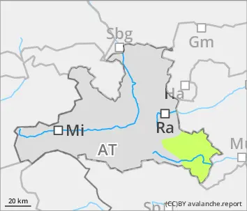
2400m
Persistent weak layer at high altitudes: caution!
Avalanche danger abover 2400m is moderate, below that altitude danger is low. Main danger: persistent weak layer Slabs can be triggered even by one single skier, particularly on W/N/E facing slopes, in transitions from shallow to deep snow. Avalanches can reach medium size During the course of the day, small wet-snow slides can trigger naturally due to higher temperatures and solar radiation, particularly on south-facing slopes below 2400m and in extremely steep terrain (>40°). In addition, small glide-snow avalanches are possible in all aspects at any time of day or night. Small slabs in the snowdrifts are triggerable only in few places: near ridglines, on shady slopes from minimum additional loading.
Snowpack
In high alpine regions there are faceted layers inside the old snowpack which are often covered by hardened layers. In addition, there are still loose layers near the surface which are covered. At lower and intermediate altitudes the snowpack is moistened by higher temperatures, in places it is completely wet. Overnight a melt-freeze crust can form in these places which then softens up during the daytime. The snowpack currently evidences no marked weak layers. On grass-covered slopes and over rocky plates, the entire snowpack can start to glide.
Tendency
Increasing avalanche danger levels expected due to fresh snow and wind impact.