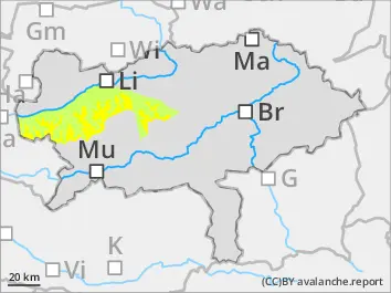
Above tree line medium avalanche danger due to snowdrift! During the day wet snow activity.
The Avalanche danger above the tree line is moderate, below that: low. smal driftsnow deposits behind ridgelines in the eastern sector are dangerous. Low additional loads can trigger slab avalanches. During the day small spontaneous loose-snow avalanches are to expect.
Snowpack
The snow base doesn’t show significant weak layers. Only in high shady slopes faceted snow layers are found. In the eastern sector small driftsnow deposits have formed on Saturday evening. Between driftsnow and snow base weak layers are possible. Due to warming and sunlight the snow layer on low southern areas will wet and intermittently destabilized.
Tendency
Tuesday will be unusually warm, Wind slab problems and avalanche danger are decreasing.
Danger level
Avalanche Problem
Wet snow
Avalanche danger low but danger spots due to wet snow in low altitudes.
The Avalanche danger is generally low. Caution: small spontaneous loose-snow avalanches especially on sunny slopes.
Snowpack
South of the Alps the snow base is small without significant weak layers. In high shady slopes some faceted snow layers are located which provide little stability. Due to warming and sunlight the snow layer will get wet and destabilized on southern sunny slopes.
Tendency
Tuesday will be unusually warm, and free from precipitation. The avalanche danger stays low.
Danger level
1400m
Avalanche Problem
Wind slab
1400m
Wet snow
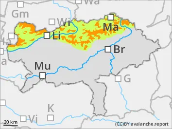
Considerable avalanche danger in high altitudes due to snowdrift! During the day the warning can cause spontaneous avalanches!
Considerable avalanche danger above 1.400 m AMSL! In low altitudes the avalanche danger scale stays low. Fresh drift snow deposits are dangerous in the eastern sector adjacent to ridgelines as well as in slopes. Low additional loads can trigger Medion slab avalanches. During the day spontaneous avalanches can occur due to warming. Their sizes are medium in high altitudes but low in low altitudes.
Snowpack
The snow base is in general compact only in high shady slopes the base is composed of faceted snow. During Saturday evening drift snow layer have formed which are not yet efficiently bonded with the snow base. Sunday night additional drift snow in the eastern sector is called (prognosis models differ significantly). Weak layers within the snowdrift as well as to the snow base are to expect. Strong warming and rain up to high high altitudes can lead to destabilization.
Tendency
Tuesday will be unusually warm, Wind slab problems and avalanche danger are decreasing.