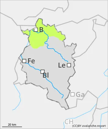
Avalanche.report

Saturday 7 December 2024

Published 7 Dec 2024, 08:19:00


Danger level

treeline
Avalanche Problem
Wind slab
Treeline


Rising avalanche danger above the treeline due to fresh snow and wind

Above the treeline, fresh snowdrifts are accumulating. They are often prone to triggering and easily triggered as a slab avalanche. Their magnitude and spread tend to increase with ascending altitude. Avalanche headquarters currently has little data from outlying regions about the snowpack, for that reason a cautious on-site evaluation is important. Below the treeline, avalanche danger is low. Isolated danger zone for small triggerings (slides) are possible in steep terrain. The risks of being swept along and forced to take a fall need to be considered.

Snowpack

Up to intermediate altitudes, the shallow snowpack has been weakened by rainfall. During the coming night of partially clear skies, it will regain firmness. By Saturday evening, an additional 5-10 cm of fresh snow is anticipated, to be transported by winds. Above the treeline, and with ascending altitude, particularly in ridgline and pass areas, fresh and initially small snowdrift accumulations will be generated. They are prone to triggering in ridgeline zones and, in particular, in steep wind-loaded gullies and bowls.

Tendency

As a result of some fresh fallen snow and wind influence, avalanche danger can rise further by Sunday.


Danger level

treeline
Avalanche Problem
Wind slab
Treeline
No distinct avalanche problem
Treeline


Rising avalanche danger above the treeline due to fresh snow and wind.

Fresh snow is expected: 5-10 cm. Above the treeline, fresh, small snowdrift accumulations will be generated. Avalanche headquarters currently has little data from outlying regions about the snowpack, for that reason a cautious on-site evaluation is important. Below the treeline, avalanche danger is low. Isolated danger zone for small triggerings (slides) are possible in steep terrain.

Snowpack

Up to intermediate altitudes, the shallow snowpack has been weakened by rainfall. During the coming night of partially clear skies, it will regain firmness. By Saturday evening, an additional 5-10 cm of fresh snow is anticipated, to be transported by winds. Above the treeline, and with ascending altitude, particularly in ridgline and pass areas, fresh and initially small snowdrift accumulations will be generated. They are prone to triggering in ridgeline zones and, in particular, in steep wind-loaded gullies and bowls.Rising avalanche danger above the treeline due to fresh snow and wind

Tendency

As a result of some fresh fallen snow and wind influence, avalanche danger can rise slightly.