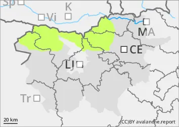
Danger level
 |
|  |  | |||||
| |  |


![]()
As the weather cools, the danger of Avalanches will be low
The old snow cover is mostly well transformed, cohesive and stable. The danger of wet snow avalanches has been reduced. Only a few avalanches will be possible. A small amount of new snow has fallen in recent days, especially in the high alpine regions. Smaller snow accumulations have formed and may be potentially unstable.
Snowpack
dp.10: springtime scenario
If the weather clears, the snowpack will freeze more markedly at night. During the day, the snow will refreeze. During the day, the zero isotherm will rise to an altitude of around 2400 m above sea level. In recent days, 5 to 10 cm of New fallen snow has fallen above about 2000 m. Precipitation has been patchy with showers. Even in the high alpine regions, showers have been quite heavy. The layers of snow are mostly well connected in the old snow cover. Individual weak layers of faceted snow crystals and abrasive grains occur more or less deep below the surface, and are more frequent on arable slopes above 1800 m.
Tendency
At the end of the week it will be quite clear and warmer every day. The snowpack will be hard and frosty in the morning. It will become a little heavier again during the day. Avalanches of packed snow will be possible, especially in the high alpine regions where there is still some unprocessed snow.