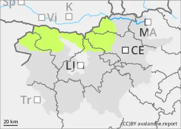
Danger level
 | 2000m |
|  |
|  | ||||
|  | |


![]()
As the weather cools, the danger of Avalanches will decrease
The old snow cover is mostly well transformed, cohesive and stable. The danger of wet snow avalanches has been reduced. The exception is isolated parts of the high alpine regions above about 2000 m, where some New fallen snow has fallen in recent days. This may become slightly thinner and less stable during the day, especially on sunny slopes. Small wet snow avalanches are possible.
Snowpack
dp.10: springtime scenario
If the weather clears, the snowpack will freeze better at night. During the day, the snow will become slightly lighter in the mid-mountains and on the sunny slopes of the high alpine regions. The zero isotherm will be around 1800 m above altitudes. On Sunday and Monday, 5 to 10 cm of new fallen snow fell above about 2000 m. Precipitation was patchy with showers. The snow has been quite heavy even in the high alpine regions. The layers of snow are mostly well connected in the old snow cover. Individual weak layers of faceted snow crystals and abrasive grains occur more or less deep below the surface, and are more frequent on arable slopes above 1800 m.
Tendency
Wednesday will be clear at first, with some variable cumulus cloud during the day. It will be a little cooler. Temperatures will be around 0 °C at 1500 m and -8 °C at 2500 m. Mostly moderate northerly winds will blow. The snowpack will remain quite hard and frosty. The danger of avalanches will be slightly reduced, but the danger of slipping will increase.