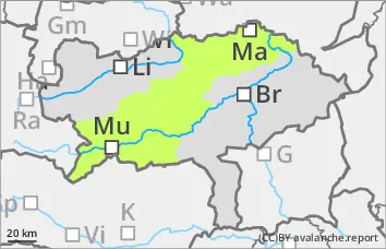
Danger level
 |
|  |  |

![]()
Moderate avalanche danger due to lack of outgoing longwave radiation and precipitation
Due to the partly cloudy night, the snowpack cannot consolidate sufficiently, so the avalanche risk is already moderate in the morning hours. With increasing warming and the onset of rain, there will be further destabilisation. Wet loose snow and slab avalanches can be triggered spontaneously from terrain that has not yet been unloaded, as well as by small additional loads from individuals, and usually reach small to medium size. Gliding avalanches are also possible in isolated cases.
Snowpack
The snowpack can only consolidate slightly during the night due to partly cloudy conditions. As it warms up and precipitation falls, it will quickly soften further and become increasingly moist. As soaking progresses, the snowpack loses firmness in all aspects, and weak layers in the persistent weak layer can be reactivated, especially on the north side. The snow can begin to glide on smooth surfaces. The snow cover is rapidly thinning out.
Tendency
The new week will bring changeable and sometimes very windy April weather. A few centimetres of new fallen snow in the form of showers will only accumulate at higher altitudes. The wet snow problem remains dominant despite a slight cooling.