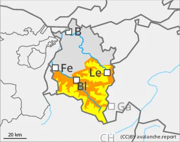
Naturally triggered avalanches expected during course of day
Rapidly rising wet-snow avalanche danger during course of day
In areas with starkly reduced nocturnal longwave outgoing radiation, the frequency of danger zones will swiftly increase due to daytime warming and initially diffuse solar radiation. Persons can trigger wet slab avalanches in afternoon and naturally triggered avalanches can be expected in all aspects below about 2500m and above that on sunny slopes. Caution urged on on steep shady slopes at 2200-2500m if the breakable crust breaks through or in case of large sink-in depths. Particularly there, wet-snow avalanches can fracture and grow to large size. Avalanche can plummet into steep gullies and green zones. Backcountry tours and ascents to refuges need to be launched early and come to an end early. In addition, winter sports enthusiasts can trigger isolated avalanches in near-surface weak layer on high-altitude shady slopes. Such danger zones are impossible to recognize.
Snowpack
As a result of reduced outgoing radiation, the snowpack can hardly freeze at night. At altitudes of 1800-2500m the ground level rotten snow is thoroughly wet even on north-facing slopes and prone to triggering. On high-altitude shady slopes there are unfavorable intermediate layers in the uppermost layer of the snowpack which in places can be triggered. A thick mid-section of compact layers blankets the deep hoar and faceted crystals at the base of the snowpack.
Tendency
Increasing impact from a high-pressure front will bring dry, predominantl sunny days and nights of clear skies. Avalanche danger will increase with the daily daytime danger cycle (daytime warming and solar radiation).
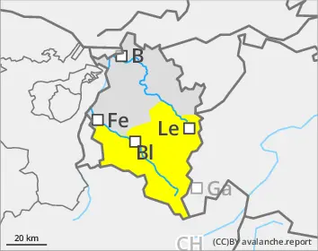
Danger level
Avalanche Problem
Wet snow
Wet-snow danger in very steep terrain where there is still lots of snow
Persons can trigger wet-snow avalanches in very steep terrain. Danger zones generally occur only in summit zones of the Bregenzerwald mountains. Avalanches generally remain medium-sized. On steep, smooth-ground slopes with lots of snow which have not yet discharged, glide-snow avalanches can trigger in all aspects.
Snowpack
Due to reduced nocturnal longwave outgoing radiation and ongoing mild temperatures, the snowpack does not freeze at night. At all altitudes the snowpack is thoroughly wet.
Tendency
On Wednesday night, still reduced outgoing longwave radiation is again anticipated. Gradually, high-pressure front conditions with mild temperatures will prevail. The slopes are continually becoming bare of snow.
Danger level
Avalanche Problem
Wet snow
Wet-snow danger in very steep terrain where there is still lots of snow
Persons can trigger wet-snow avalanches in very steep terrain. Danger zones generally occur only in summit zones of the Bregenzerwald mountains. Avalanches generally remain medium-sized. On steep, smooth-ground slopes with lots of snow which have not yet discharged, glide-snow avalanches can trigger in all aspects.
Snowpack
The snowpack generally cannot freeze enough at night to bear loads. At all altitudes the snowpack is thoroughly wet up to summit zones.
Tendency
On Wednesday night, still reduced outgoing longwave radiation is again anticipated. Gradually, high-pressure front conditions with mild temperatures will prevail. The slopes are continually becoming bare of snow.
Danger level
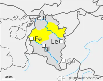
Avalanche Problem
Wet snow
Small wet-snow slides possible
Persons can trigger wet loose-snow avalanches in steep terrain where there is sufficient snow on the ground. Avalanches will be mostly small-sized.
Snowpack
The ground is largely bare of snow. Where there is a snowpack, it is thoroughly wet.
Tendency
Gradually, high-pressure front conditions with dry air, sunny days and nights of clear skies will prevail. The slopes are continually becoming bare of snow.
Danger level
Avalanche Problem
Wet snow
Small wet-snow slides possible
Persons can trigger wet loose-snow avalanches in steep terrain where there is sufficient snow on the ground. Avalanches will be mostly small-sized.
Snowpack
The ground is largely bare of snow. Where there is a snowpack, it is thoroughly wet.
Tendency
Gradually, high-pressure front conditions with mild temperatures will prevail. The slopes are continually becoming bare of snow.