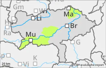
Danger level
 |
|  |  | |||||
|  |
|  |


![]()
Moderate avalanche danger, wet snow danger remains a priority throughout the day
The avalanche risk is moderate. There is a danger of wet loose snow and slab avalanches throughout the day from terrain that has not yet been unloaded as rain, incoming radiation and warming increase. These can detach themselves or be triggered by a small additional load from people and are usually small to medium-sized. Only in a few extremely steep, shady areas above 2200 metres are there avalanche prone locations for small to medium-sized dry slab avalanches. Gliding avalanches are possible in isolated cases.
Snowpack
At night, the isothermal snow cover at high altitudes can consolidate slightly due to outgoing longwave radiation. However, it quickly softens again with rain, radiation and warming. The soaking can reactivate old weak layers in the persistent weak layer, especially on the north side. In all aspects, the soaked snowpack can lose its stability or begin to glide on slippery ground. At low altitude and on the sunny slopes, the snow cover is developing rapidly.
Tendency
On Friday, the weather will gradually calm down with slightly fewer cumulus clouds and a decrease in the risk of showers. There will be little change in the avalanche situation.