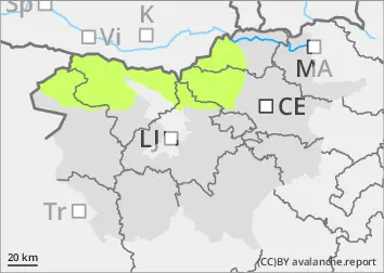
Danger level
 | 1800m |
|  |
|  | ||||
| |
|  |


![]()
Some wet snow avalanche cannot be ruled out
The snowpack is mostly well connected and generally stable. During the day, wet snow avalanches will be possible in a few places. Weak layers in old snow deeper in the snowpack also pose a minor danger. These weak layers are more common in the axis above the forest. In particular, a small to medium avalanche can be triggered by a large load exceeding the load-bearing capacity of these layers.
Snowpack
dp.10: springtime scenario
The snowpack will partly freeze overnight, but less than in recent days due to a cloudier night. During the day, the snow will become heavier and may become unstable in places. In the old snow cover, the snow layers are mostly well connected. More or less deep below the surface, there are several weak layers of slush and discontinuous grains, which are more frequent on slopes at low tide.
Tendency
Sunday will be clearer and warmer again. Isolated avalanches of southern snow are possible in the mid-day and afternoon.