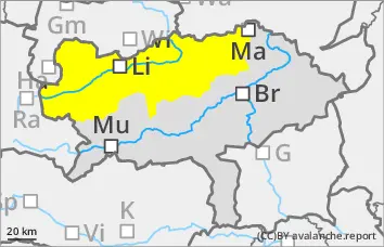
Strong increase in avalanche danger already in the morning!
Spontaneous wet snow avalanches to be expected!
The avalanche danger is generally categorised as "moderate", but increases slightly during the course of the day. Spontaneous avalanche activity increases with the sunlight from midday. Medium-sized and occasionally large wet loose snow and slab avalanches are to be expected in particular on the sunny slopes. Gliding avalanches are also to be expected on the sunny slopes. In extremely steep, shady areas above 2000 m, small to medium-sized slab avalanches can also be triggered in isolated cases (persistent weak layer problem).
Snowpack
The snowpack is damp or wet in all layers and can start to glide on slippery ground. In addition to loose snow avalanches, spontaneous, wet slab avalanches can also be expected, as liquid water in the snowpack can reactivate former weak layers in the persistent weak layer. Only in very shady areas above 2000 m does the snowpack still have cold reserves and some weak layers in the persistent weak layer.
Tendency
Sunny mountain weather will prevail again on Tuesday. The north-westerly wind blows noticeably. The avalanche danger changes only slightly.
EARLIER Danger level
Avalanche Problem
Wet snow
Persistent weak layer
2000m
LATER Danger level
Avalanche Problem
Wet snow
Persistent weak layer
2000m
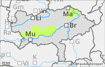
Increase in avalanche danger already in the morning!
Spontaneous wet snow avalanches to be expected!
The avalanche danger increases from low to moderate during the course of the day. Spontaneous avalanche activity increases during the day with the sunshine. Small to medium-sized wet loose snow and slab avalanches are to be expected in particular on sunny slopes. In extremely steep, shady areas above 2000 m, small to medium-sized slab avalanches can also be triggered very occasionally (persistent weak layer problem).
Snowpack
The snowpack is damp or wet in all areas and can start to glide on slippery surfaces. Only in very shady areas above 2000 metres does the snowpack still have cold reserves and in some cases weak layers in the persistent weak layer. In general, there is little snow and lower altitudes are increasingly thinning out.
Tendency
Sunny mountain weather will prevail again on Tuesday. The north-westerly wind blows noticeably. The avalanche danger changes only slightly.
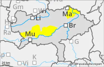
EARLIER Danger level
Avalanche Problem
Wet snow
Persistent weak layer
2000m
LATER Danger level
Avalanche Problem
Wet snow
Persistent weak layer
2000m
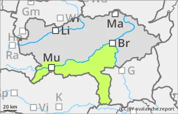
Low avalanche danger, but watch out for spontaneous wet snow slides!
The avalanche danger is assessed as "low". Nevertheless, small, wet loose snow slides and occasional small gliding avalanches are to be expected (wet snow problem). In extremely steep, shady areas above 2000 m, small to medium-sized slab avalanches can still be triggered very occasionally (persistent weak layer problem).
Snowpack
The thin snowpack will be damp or wet in all areas and may start to glide on a smooth surface. Only in very shady areas above 2000 metres does the snowpack still have small cold reserves and occasional weak layers in the persistent weak layer. In general, there is very little snow and lower altitudes are becoming increasingly thin.
Tendency
Sunny mountain weather will prevail again on Tuesday. The north-westerly wind blows noticeably. The avalanche danger remains low.