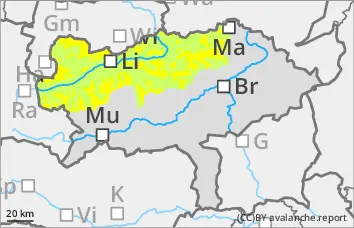
The avalanche danger is rated as "moderate" above 1800 metres. Avalanche prone locations are mainly in shady areas at high altitudes, where slab avalanches can be triggered by large additional loads and occasionally also by small additional loads. Mainly medium-sized avalanches are expected, but they can also become large in isolated cases. Spontaneous, wet loose snow avalanches and occasional gliding avalanches are to be expected on the sunny slopes.
Snowpack
The thick snowdrift accumulations of the past few days have settled and are hardly prone to triggering. However, at higher elevations, a weak layer has formed in the transition to the largely stable old snow foundation. At medium elevations and sunny slopes up to the higher elevations, the snow cover is becoming increasingly isothermal and moist, losing stability or starting to glide on a smooth surface. At lower altitudes, the snowpack is increasingly thinning out.
Tendency
Mild mountain weather with plenty of sunshine and little wind on Easter Sunday. The wet and gliding snow problem is becoming increasingly important, the persistent weak layer problem is easing.
Danger level
1900m
Avalanche Problem
Persistent weak layer
1900m
Wet snow
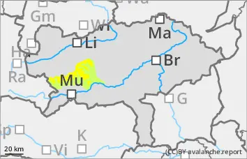
Moderate avalanche danger at high altitudes!
The avalanche danger above 1900 metres is rated as "moderate". Avalanche prone locations are older snowdrift accumulations, which can be triggered as smaller slab avalanches, especially in shady areas of the higher elevations due to large additional loads, occasionally also due to small additional loads. Wet snow slides and occasional gliding avalanches are increasingly to be expected on sunny slopes.
Snowpack
The snowpack is becoming increasingly isothermal and moist in mid-altitudes and sunny slopes up to high altitudes, losing some of its stability as a result or may start to glide on a smooth surface. Only in shady high altitudes are there still cold reserves and a somewhat weakened snow base, fundament due to a moderate persistent weak layer problem. Generally speaking, there is little snow and lower altitudes are increasingly thinning out.
Tendency
Mild mountain weather with plenty of sunshine and little wind on Easter Sunday. The wet and gliding snow problem is becoming increasingly important, the persistent weak layer problem is easing.
Danger level
Avalanche Problem
Wet snow
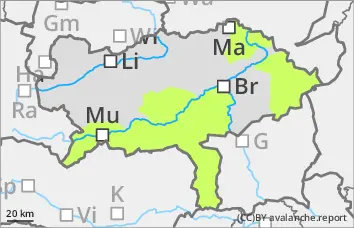
Low avalanche danger, but watch out for wet snow slides on the sunny slopes!
The avalanche danger is assessed as "low". Nevertheless, there are very isolated avalanche prone locations in shady areas at high altitudes where small slab avalanches can be triggered. On the sunny slopes, wet loose snow slides and occasional gliding avalanches are to be expected.
Snowpack
The snowpack is becoming increasingly isothermal and moist in mid-altitudes and sunny slopes up to high altitudes, losing a little stability as a result or may start to glide on a smooth surface. Only in shady high altitudes are there still small cold reserves and a somewhat weakened snow base, fundament due to a moderate persistent weak layer problem. Generally speaking, there is little snow and lower altitudes are increasingly thinning out.
Tendency
Easter Sunday will see mild mountain weather with plenty of sunshine and little wind. The avalanche risk remains low.