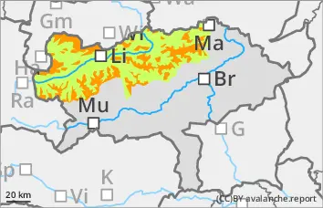
Still considerable avalanche danger at higher altitudes!
The avalanche danger above 1600 m is assessed as "considerable". Persistent winds lead to extensive snowdrift accumulations, some of which are prone to triggering. Avalanche prone locations are mainly in gullies, bowls and behind ridgelines and terrain edges and sometimes extend down into forest aisles. Aspects from north to east to south are particularly affected. The drifting snow layer can be triggered in some places by a small additional load as a mostly medium-sized slab avalanche. Occasionally, large avalanches can also occur.
Snowpack
The new fallen snow and winds of the past few days have created snowdrift accumulations, some of which are very thick and are deposited on a largely stable old snowpack. The proneness to triggering of weak layers in the windslab snow is decreasing, but weak layers in the transition to persistent weak layers and in the snow base, fundament are still possible, especially on the north side.
Tendency
On Friday, there will still be a few clouds from the north, but it will soften a little during the daytime changes. In the south of the Alps, it will be cloudy in the morning and sunny in the afternoon. The wind slab problem will slowly subside.
Danger level
treeline
Avalanche Problem
Wind slab
Treeline
Persistent weak layer
1800m
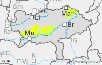
Still wind slab problem in the high altitudes!
The avalanche danger is rated as "moderate" above the tree line. There, fresh snowdrift accumulations can still be triggered as slab avalanches by low additional loads. Medium-sized avalanches are typically expected. The avalanche prone locations are on lee slopes behind terrain edges and in steep gullies and bowls.
Snowpack
Strong winds are still forming fresh snowdrift accumulations. These are located on a mostly stable old snowpack. There are weak layers in the wind-driven snow and occasionally, in shady high altitudes, also in the snow base, fundament (persistent weak layer problem).
Tendency
On Friday, there will still be a few clouds from the north, but it will soften a little during the daytime changes. In the south of the Alps, it will be cloudy in the morning and sunny in the afternoon. The avalanche risk will change only slightly.
Danger level
1500m
Avalanche Problem
Wind slab
1500m
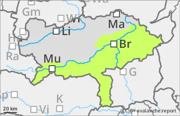
Low avalanche danger, but avoid fresh pillows of wind drifted snow!
The avalanche danger is assessed as "low". Nevertheless, isolated pillows of wind drifted snow can be triggered as small slab avalanches.
Snowpack
Persistent winds still lead to the formation of small pillows of wind drifted snow, which are deposited on a hard old snowpack and are usually sufficiently bonded to it. There is generally little snow.
Tendency
On Friday, it will be cloudy on the south side of the Alps in the morning and sunny in the afternoon. The avalanche risk remains low.