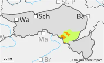
Above 1400 metres there is still a considerable avalanche risk (level 3)
Strong to stormy winds have been blowing almost continuously since Wednesday, transporting the fresh new fallen snow. The avalanche prone locations are adjacent to ridgelines and distant from ridgelines in almost all aspects. Particular caution is required in the transition from a little to a lot of snow as well as in gullies, bowls and behind terrain edges. The sometimes thick layers of drifting snow can be triggered by individuals as a medium-sized avalanche. Defensive behaviour is recommended for winter sports in open terrain.
Snowpack
In the last few days, up to 50 cm of new fallen snow has fallen under stormy winds and extensive snowdrift accumulations have formed. The new fallen snow forecast for Tuesday will again be accompanied by strong winds, which will further exacerbate the drift snow situation.
There are weak layers within the drift snow packs. There are still faceted crystals or floating snow in the old snowpack in shady high areas. However, these are hardly noticeable and do not pose a significant avalanche problem. There is less snow at low altitudes, especially on sunny slopes.
Tendency
The avalanche risk remains considerable at higher altitudes. The north to north-westerly winds will continue to blow strongly, at times gale force - fresh snowdrift accumulations will be deposited on the already existing snowdrift accumulations, which are prone to triggering.
The weather will begin to improve from the north-east on Wednesday. After a lot of clouds in the first half of the day, there will be more clearing in the afternoon.
Danger level
1200m
Avalanche Problem
Wind slab
1200m
Pay attention to prone to triggering snow packs!
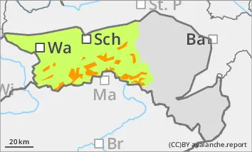
Above 1200 metres, there is still a considerable avalanche risk (level 3).
Strong to stormy winds have been blowing almost continuously since Wednesday, transporting the fresh new fallen snow. The avalanche prone locations are adjacent to ridgelines and distant from ridgelines in almost all aspects. Particular caution is required in the transition from a little to a lot of snow as well as in gullies, bowls and behind terrain edges. The sometimes thick layers of drifting snow can be triggered by individuals as a medium-sized avalanche. Defensive behaviour is recommended for winter sports in open terrain.
Snowpack
In the last few days, up to 70 cm of new fallen snow has fallen under stormy winds and extensive snowdrift accumulations have formed. The new fallen snow forecast for Tuesday will again be accompanied by strong winds, which will further exacerbate the drift snow situation.
There are weak layers within the drift snow packs. There are still faceted crystals or floating snow in the old snowpack in shady high areas. However, these are hardly noticeable and do not pose a significant avalanche problem. There is less snow at low altitudes, especially on sunny slopes.
Tendency
The avalanche risk remains considerable at higher altitudes. The north to north-westerly winds will continue to blow strongly, at times gale-force - fresh snowdrift accumulations will be deposited on the already existing snowdrift accumulations, which are prone to triggering.
The weather will begin to improve from the north-east on Wednesday. After a lot of clouds in the first half of the day, there will be more clearing in the afternoon.
Danger level
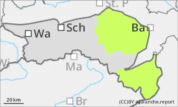
Partly prone to wind drifted snow at medium altitudes.
Pillows of wind drifted snow are sometimes prone to triggering and can be triggered by individuals as a small slide. However, the risk of burial is low. The snowpack can start to glide snow on steep grassy slopes.
Snowpack
In the last few days, up to 40 cm of new fallen snow has fallen in the Gutenstein Alps and up to 20 cm on the Hochwechsel and in the Bucklige Welt. Since Wednesday, strong to gale-force winds have been blowing almost continuously in places, transporting the fresh new fallen snow. This is now forming drift snow packs in forest aisles and higher elevations.
At low altitudes, the snow is mostly wet.
Tendency
The avalanche risk is not expected to increase.
The north to north-westerly wind is still blowing strongly, sometimes gale force - fresh drift snow packs are being deposited on the existing accumulations that are prone to triggering.