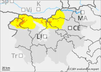
New fallen snow - strong northerly winds in the high alpine regions
On Wednesday, showers will occur in the north overnight. The snowfall level will initially be around 1500 m and will descend rapidly. The snow will weaken by Thursday morning. By then, 20-40 cm of New fallen snow is expected to fall in the mountains. After the passage of the cold front, a strong northerly wind will blow, carrying New fallen snow and building up new snow layers on the southern flanks.
New fallen snow and blowing snow are the main dangers. Danger is increased especially in sloping terrain and in ravines where the height of New fallen snow is higher due to snow accumulations.
In addition to new fallen snow, weak layers in the snowpack deeper in the snowpack can be a local problem. These weak layers are more prevalent in the axis above the forest. In particular, a large avalanche can be triggered if the load exceeds the load-bearing capacity of these layers.
The situation is challenging, and strong winds can lead to windfalls below the forest boundary. Visiting the mountains is not recommended!
Snowpack
dp.4: cold following warm / warm following cold
As the cold front passes, 20-40 cm of dry and light snow is expected to fall in the mountains, which will not adhere well to the old snow base. The previous snowfall has locally produced a potentially dangerous weak layer of Graupel. Locally, the layers of Graupel are 5-10 cm thick, possibly more.
In the old snow cover, the snow layers are mostly well connected. Deep below the surface, several weak layers of shreds and sheared grains occur, especially on the axial sides.
Tendency
Avalanche and weather conditions will remain challenging. We can expect another 5-15 cm of new fallen snow on Friday. Strong northerly winds will continue to blow, building new snow drifts.
Danger level
treeline
Avalanche Problem
New snow
Treeline
Wind slab
Treeline
New snow
Treeline
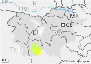
New fallen snow - strong northerly winds in the high alpine regions
On Thursday it will snow, with a snowfall level around 700 m during the day. In the mountains, a greater amount of fresh snow will fall, 40-60 cm is expected. Strong north-easterly winds will pick up during the day, carrying New fallen snow and building up new snow layers on the southern sides.
New fallen snow and blowing snow are the main dangers. Danger is increased especially in sloping terrain and in ravines where the height of New fallen snow is higher due to snow accumulations. In the mountains, bonded snow will not adhere well to the old snow base.
Conditions are challenging, with strong winds that may cause windfalls below the tree line. We advise against visiting the mountains!
Snowpack
dp.4: cold following warm / warm following cold
As the cold front passes, 40-60 cm of dry and light snow is expected to fall in the mountains, which will not adhere well to the old snow base. The previous snowfall may have locally produced a potentially dangerous weak layer of Graupel. In the old snow cover, the snow layers are mostly well interconnected.
Tendency
Avalanche and weather conditions will remain challenging. Around 10 cm of new fallen snow can be expected on Friday. Strong northerly winds will continue to blow, carrying New fallen snow.