Due to fresh snow and wind, marked rise in avalanche danger
As a result of large amounts of fresh snow and drifts, naturally triggered slab avalanches can be expected. They can grow to large size and plummet over and past flattish terrain. Outside of that, avalanches can easily be triggered by one single winter sports enthusiast, even in flattish parts of slopes. Danger zones occur over far-reaching areas, and increase during the course of the forecast period as precipitation increases. For activities outside the secured slopes in ski areas, conditions are extremely critical.
Snowpack
Widespread snowfall of 50-70cm is expected. Brisk winds with strong-velocity gusts will transport the new fallen snow far-reachingly. Fresh snow and drifts lie deposited on shady slopes atop a loosely-packed surface, on sunny slopes atop a melt-freeze crust. Beneath a further melt-freeze crust in the uppermost third of the snowpack there are often faceted crystals. The mid-section of the snowpack consists widespread of well consolidated, compact layers which on shady high altitude slopes blanket a poorly-structured old snowpack fundament.
Tendency
As the precipitation tapers off, naturally triggered avalanche activity will diminish on Friday. Avalanches can still be triggered easily.
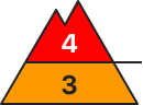
Danger level
Avalanche Problem
New snow
Naturally triggered avalanches can be expected
Due to fresh snow and wind, marked rise in avalanche danger
As a result of large amounts of fresh snow and drifts, naturally triggered slab avalanches can be expected. They will mostly be medium-sized. Outside of that, avalanches can easily be triggered by one single winter sports enthusiast, even in flattish parts of slopes. Danger zones occur over far-reaching areas, and increase during the course of the forecast period as precipitation increases. For activities outside the secured slopes in ski areas, experience in assessing the terrain and avalanche risks are imperative. A defensive route selection is recommended.
Snowpack
Widespread snowfall of 30-50cm is expected. Brisk winds with strong-velocity gusts will transport the new fallen snow far-reachingly. Fresh snow and drifts lie deposited on shady slopes atop a loosely-packed surface, on sunny slopes atop a melt-freeze crust. The old snowpack consists widespread of well consolidated, compact layers.
Tendency
As the precipitation tapers off, naturally triggered avalanche activity will diminish on Friday. Avalanches can still be triggered easily.
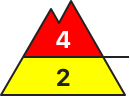
Danger level
Avalanche Problem
New snow
Persistent weak layer
2200m
Naturally triggered avalanches can be expected
Due to fresh snow and wind, marked rise in avalanche danger
As a result of large amounts of fresh snow and drifts, naturally triggered slab avalanches can be expected. They will mostly be medium-sized. Outside of that, avalanches can easily be triggered by one single winter sports enthusiast, even in flattish parts of slopes. Danger zones occur over far-reaching areas, and increase during the course of the forecast period as precipitation increases. For activities outside the secured slopes in ski areas, experience in assessing the terrain and avalanche risks are imperative. A defensive route selection is recommended.
Snowpack
Widespread snowfall of 30-50cm is expected. Brisk winds with strong-velocity gusts will transport the new fallen snow far-reachingly. Fresh snow and drifts lie deposited on shady slopes atop a loosely-packed surface, on sunny slopes atop a melt-freeze crust. Beneath a further melt-freeze crust in the uppermost third of the snowpack there are often faceted crystals. The mid-section of the snowpack consists widespread of well consolidated, compact layers which on shady high altitude slopes blanket a poorly-structured old snowpack fundament.
Tendency
As the precipitation tapers off, naturally triggered avalanche activity will diminish on Friday. Avalanches can still be triggered easily.
Danger level
treeline
Avalanche Problem
New snow
Treeline
New snow
Treeline
Persistent weak layer
2000m
Gliding snow
2000m
Lots of new fallen snow: avalanches can get big.
The avalanche risk is high above the tree line and moderate below it. The main problem is new fallen snow. The many avalanche prone locations are in steep terrain adjacent to ridgelines in all aspects, behind slope discontinuities and in gullies and bowls. Slab and loose snow avalanches can detach themselves and become large.
In the Allgäu in particular, gliding avalanches can detach themselves on previously apery, very steep meadow slopes. They can reach medium size.
Snowpack
Around 50 cm of new fallen snow has already fallen locally. The snowfall was accompanied in places by strong, sometimes gale-force winds from the north-west. It continues to snow. The large amount of new and drifting snow is lying on soft snow on the northern sides of higher elevations and is prone to triggering. Weak layers prone to triggering are also embedded within the wind slab. The snowdrift accumulations are large and partly covered by new fallen snow. In the higher elevations, weak layers of faceted crystals can be found near the surface. Otherwise, the underlying old snowpack is generally well stabilised. On the southern slopes, the new fallen snow covers the previously apery ground and begins to glide snow.
Tendency
The avalanche danger will decrease somewhat after the fresh snowfall.
Danger level
treeline
Avalanche Problem
New snow
Treeline
New snow
Treeline
Persistent weak layer
2000m
Dangerous - large amounts of new snow and sometimes stormy winds.
The avalanche risk is high above the tree line (even in sparse high forest) and moderate below.
New fallen snow and extensive snowdrift accumulations are very easy to disturb in many places above the tree line in all aspects. Snow slabs can be triggered in layers close to the surface and become medium to large. Especially on western, northern and eastern slopes, avalanches can also tear through layers of the snowpack close to the ground. In some cases, the wind slab is covered by snow again away from areas adjacent to the ridgeline, crest or summit, making avalanche prone locations difficult to recognise.
Naturally triggered avalanches (both slabby and soft) are to be expected in steep terrain.
Snowpack
Wind slab (partly covered by snow) lies on a weak old snowpack. There are weak layers in the upper part of the old snowpack as well as deeper down (faceted crystals on crusts). Close to the ground, the snowpack consists of angular, cup-shaped crystals. Snow slabs break mainly within the fresh wind slab and new fallen snow layers, as well as on one of the uppermost weak layers in the persistent weak layer. Under unfavourable circumstances, however, a weak layer close to the ground can also be affected.
Tendency
As the snowfall subsides, the risk of avalanches decreases.
Danger level
1700m
Avalanche Problem
New snow
1700m
Wind slab
1700m
Persistent weak layer
1700m
New snow
1700m
New fallen snow - strong northerly winds in the high alpine regions
On Wednesday, showers will occur in the north overnight. The snowfall level will initially be around 1500 m and will descend rapidly. The snow will weaken by Thursday morning. By then, 20-40 cm of New fallen snow is expected to fall in the mountains. After the passage of the cold front, a strong northerly wind will blow, carrying New fallen snow and building up new snow layers on the southern flanks.
New fallen snow and blowing snow are the main dangers. Danger is increased especially in sloping terrain and in ravines where the height of New fallen snow is higher due to snow accumulations.
In addition to new fallen snow, weak layers in the snowpack deeper in the snowpack can be a local problem. These weak layers are more prevalent in the axis above the forest. In particular, a large avalanche can be triggered if the load exceeds the load-bearing capacity of these layers.
The situation is challenging, and strong winds can lead to windfalls below the forest boundary. Visiting the mountains is not recommended!
Snowpack
dp.4: cold following warm / warm following cold
As the cold front passes, 20-40 cm of dry and light snow is expected to fall in the mountains, which will not adhere well to the old snow base. The previous snowfall has locally produced a potentially dangerous weak layer of Graupel. Locally, the layers of Graupel are 5-10 cm thick, possibly more.
In the old snow cover, the snow layers are mostly well connected. Deep below the surface, several weak layers of shreds and sheared grains occur, especially on the axial sides.
Tendency
Avalanche and weather conditions will remain challenging. We can expect another 5-15 cm of new fallen snow on Friday. Strong northerly winds will continue to blow, building new snow drifts.
Danger level
treeline
Avalanche Problem
New snow
Treeline
New snow
Treeline
Persistent weak layer
2000m
Gliding snow
2000m
The number and extent of avalanche prone locations increase with altitude.
The avalanche risk is considerable above the tree line and moderate below it. The main problem is new fallen snow. The avalanche prone locations are in steep terrain adjacent to ridgelines in all aspects, behind slope discontinuities and in gullies and bowls. Slab and loose snow avalanches can detach themselves and reach medium size. Occasionally, avalanches with a large additional load, for example from a superficial avalanche, can be triggered in deeper weak layers and become large.
In the Allgäu in particular, gliding avalanches can detach themselves on previously aperic, very steep meadow slopes. They can reach medium size.
Snowpack
Up to 40 cm of new fallen snow has already fallen, especially in the western regions. This was accompanied by strong, sometimes stormy winds from the north-west. It continues to snow. The new and drifting snow is lying on soft snow on the northern sides of higher elevations and is prone to triggering. Weak layers prone to triggering are also embedded within the wind slab. The snowdrift accumulations are becoming large and are partly covered by new fallen snow. In the higher elevations, weak layers of faceted crystals can be found near the surface. Otherwise, the underlying old snowpack is generally well stabilised. On the southern slopes, the new fallen snow covers the previously apery ground and begins to glide snow.
Tendency
With wind, the wind slab can become a problem.
Danger level
treeline
Avalanche Problem
Wind slab
Treeline
Persistent weak layer
2000m
Tricky - avoid fresh wind slab at all costs
The avalanche risk is considerable above the tree line (also in forest aisles and in sparse high forest).
New fallen snow and extensive snowdrift accumulations are very prone to triggering in some places above the tree line in all aspects. Snow slabs can be triggered in layers close to the surface and can reach medium size. Avalanches can also break through into layers of the snowpack close to the ground and become large on west, north and east-facing slopes. In some cases, the wind slab is covered by snow again, and avalanche prone locations are sometimes difficult to recognise.
Naturally triggered avalanches (both slabby and soft) are also to be expected in very steep, extreme terrain.
Snowpack
Wind slab (partly covered by snow) lies on a weak old snowpack. There are weak layers in the upper part of the old snowpack as well as deeper down (faceted crystals on crusts). Close to the ground, the snowpack consists of angular, cup-shaped crystals. Snow slabs break mainly within the fresh wind slab and new fallen snow layers, as well as on one of the uppermost weak layers in the persistent weak layer. Under unfavourable circumstances, however, a weak layer close to the ground can also be affected.
Tendency
The avalanche danger remains for the time being.
Danger level
treeline
Avalanche Problem
New snow
Treeline
Wind slab
Treeline
Persistent weak layer
2000m
Pay attention to a lot of new fallen snow and fresh, more extensive loads!
The avalanche risk is considerable above the tree line. Fresh, often extensive snowdrift accumulations due to a lot of new fallen snow and strong, sometimes stormy winds can be found in almost all aspects and can be triggered by even a small additional load (one person) in steep terrain, in filled bowls and gullies. These snow avalanches can also become large and must be taken into account. Naturally triggered avalanches and gliding avalanches below the tree line can also be expected in steep, blown-in areas with increasing amounts of new snow.
Snowpack
Abundant snowfall with strong to stormy winds form prone to triggering extensive wind slab, which binds poorly with the old snowpack and puts additional pressure on the snowpack. Inside, the old snowpack is usually compact, but often moist up to high altitudes. However, the snow base, fundament is high up and partly weakened on shady slopes. At medium and low altitudes, the snow often falls on bare ground.
Tendency
The avalanche danger is only slowly decreasing.
Danger level
Avalanche Problem
Wind slab
Caution: small snowdrifts
Fresh snow and drifts can be triggered as small-to-medium sized slab avalanches by one single winter sports enthusiast in some places. Danger zones occur behind sharp drops in the terrain and in wind-loaded gullies and bowls.
Snowpack
Widespread 10-30cm of fresh snow is anticipated. Brisk winds with strong gusts will transport this fresh snow far-reachingly. Fresh snow and drifts in general lie deposited only on shady slopes atop an old snowpack, otherwise on bare ground.
Tendency
Avalanche danger will gradually diminish
Danger level
treeline
Avalanche Problem
New snow
Treeline
Persistent weak layer
2000m
Heikel - Large amounts of new snow, partly with wind influence.
The avalanche risk is considerable above the tree line (also in forest aisles).
The large amount of new fallen snow and the extensive snowdrift accumulations on all aspects can easily be triggered above the tree line. Avalanches can start in layers close to the surface and reach medium size. Occasionally, avalanches can tear through layers of the snowpack close to the ground, especially on shady slopes. The wind slab is often covered with snow away from areas adjacent to the ridgeline and avalanche prone locations are difficult to recognise.
Naturally triggered avalanches (both slabby and soft) are also to be expected in very steep, extreme terrain.
Snowpack
Wind slab (partly covered by snow) is partly lying on a weak old snowpack. There are weak layers in the upper part of the old snowpack as well as deeper down (faceted crystals on crusts). Close to the ground, the snowpack consists of angular, cup-shaped crystals. Snow slabs break mainly within the fresh wind slab and new fallen snow layers, as well as on one of the uppermost weak layers in the persistent weak layer. Under the most unfavourable circumstances, however, a weak layer close to the ground can also be affected.
Tendency
The avalanche danger remains for the time being or is only slowly decreasing.
Danger level
treeline
Avalanche Problem
New snow
Treeline
Persistent weak layer
2000m
New fallen snow and wind - avalanches can easily be triggered!
The avalanche risk is considerable above the tree line (level 3). The new fallen snow and, in particular, the extensive snowdrift accumulations on all aspects are prone to triggering, especially above the tree line. The danger spots extend into forest aisles and sparse high forest and can be triggered by individual winter sports enthusiasts as medium-sized avalanches. They are mainly located in gullies, bowls and behind terrain edges. Occasionally, avalanches on very steep west, north and east-facing slopes above around 2000 m can also break through into layers close to the ground. In some cases, the wind slab is covered by snow again away from areas adjacent to the ridgeline, crest or summit and is difficult to recognise. Spontaneous slab avalanches and loose snow avalanches from very steep slopes cannot be ruled out.
Snowpack
20 to 40 cm of new fallen snow will be transported by strong to stormy north-westerly winds during the day. Fresh snowdrift accumulations are deposited above the tree line on a partly still weak old snowpack. They will increase in volume and size during the daytime changes. Weak layers are located in the bound layer or transition to the old snow, at higher altitudes in places still in the persistent weak layer (faceted crystals in the area of crusts) or occasionally in layers close to the ground in the form of floating snow.
Tendency
Still stormy, with 10 - 30 cm of new fallen snow, further intensification of the avalanche situation in the eastern regions!
Danger level
treeline
Avalanche Problem
New snow
Treeline
New fallen snow and stormy winds lead to a significant increase in avalanche danger!
The avalanche risk is considerable above the tree line (level 3!). New fallen snow and stormy winds create fresh snowdrift accumulations in all aspects, which can be triggered by individual winter sports enthusiasts as small to medium-sized slab avalanches. The avalanche prone locations are mainly in gullies, bowls and behind terrain edges.
Very occasionally, avalanches can also tear through layers close to the ground. Be especially careful on very steep western, northern and eastern slopes above the tree line. Transitions from a little to a lot of snow are particularly unfavourable.
Snowpack
20 to 40 cm of snow is being transported by strong to stormy north to north-westerly winds. Fresh snowdrift accumulations are deposited above the tree line on a mostly compact old snow surface. Weak layers are located within the drift snow packs or in the transition to the old snowpack. In deep layers in northern, and in some cases also in western and eastern aspects, there are still faceted crystals or floating snow in the old snowpack, but these may already be interspersed with melt-freeze crusts.
Tendency
The avalanche risk will increase on Friday.
An area of low pressure will bring another 20 to 50 cm of new fallen snow, especially in the eastern mountains. Stormy winds will continue to blow.
Danger level
treeline
Avalanche Problem
Wind slab
Treeline
Avalanche prone locations are mainly in the leeward areas.
The avalanche risk is moderate above the tree line and low below. Wind slabs are the main problem. The avalanche prone locations are in the steep terrain adjacent to ridgelines in the north to east aspects as well as in gullies and bowls. Slab avalanches can be triggered with little additional load and usually remain small.
Small gliding avalanches can release on their own on previously apery, very steep meadow slopes.
Snowpack
Around 20 to 30 cm of new fallen snow with strong, sometimes stormy winds from a north-westerly direction. Where there is still snow, the new and wind-slab snow will lie on a slightly damp surface of old snow. Only on very steep north-facing slopes at higher altitudes is it occasionally lying on soft snow. Weak layers prone to triggering may be embedded within the wind slab. The old snowpack is generally well stabilised and slightly moist. Previously bare ground is covered by new fallen snow.
Tendency
It remains windy. The wind slab problem may get a little bigger.
Danger level
treeline
Avalanche Problem
Wind slab
Treeline
Beware of fresh wind slab!
The avalanche risk is moderate above the tree line. Fresh snowdrift accumulations can be triggered as small to medium-sized avalanches by individual winter sports enthusiasts in all aspects. The avalanche prone locations are mainly in gullies, bowls and behind terrain edges.
Very occasionally, avalanches can also tear through layers close to the ground. Take particular care on very steep western, northern and eastern slopes at high altitudes. Transitions from a little to a lot of snow are particularly unfavourable.
Snowpack
10 to 20 cm of new fallen snow will be transported by strong to stormy north-westerly winds during the day. Fresh snowdrift accumulations are often deposited on a sufficiently stable old snowpack above the tree line. Weak layers are in the bound layer or transition to the old snow, at higher altitudes in places still in the persistent weak layer (faceted crystals in the area of crusts) or occasionally in layers close to the ground in the form of floating snow.
Tendency
Still stormy, significant increase in fresh snow in the north-east. The wind slab problem is getting worse!
Danger level
treeline
Avalanche Problem
New snow
Treeline
Wind slab
Treeline
New snow
Treeline
New fallen snow - strong northerly winds in the high alpine regions
On Thursday it will snow, with a snowfall level around 700 m during the day. In the mountains, a greater amount of fresh snow will fall, 40-60 cm is expected. Strong north-easterly winds will pick up during the day, carrying New fallen snow and building up new snow layers on the southern sides.
New fallen snow and blowing snow are the main dangers. Danger is increased especially in sloping terrain and in ravines where the height of New fallen snow is higher due to snow accumulations. In the mountains, bonded snow will not adhere well to the old snow base.
Conditions are challenging, with strong winds that may cause windfalls below the tree line. We advise against visiting the mountains!
Snowpack
dp.4: cold following warm / warm following cold
As the cold front passes, 40-60 cm of dry and light snow is expected to fall in the mountains, which will not adhere well to the old snow base. The previous snowfall may have locally produced a potentially dangerous weak layer of Graupel. In the old snow cover, the snow layers are mostly well interconnected.
Tendency
Avalanche and weather conditions will remain challenging. Around 10 cm of new fallen snow can be expected on Friday. Strong northerly winds will continue to blow, carrying New fallen snow.
Danger level
treeline
Avalanche Problem
Wind slab
Treeline
Persistent weak layer
2000m
Avoid fresh wind slab.
The avalanche risk is moderate above the tree line. Fresh wind slabs can be triggered by individual winter sports enthusiasts in all aspects. Avalanche prone locations are mainly in gullies, bowls and behind terrain edges. Avalanches are usually of medium size.
Occasionally, avalanches can also tear through layers of snowpack close to the ground. Take particular care on very steep western, northern and eastern slopes above around 2000 metres. Transitions from a little to a lot of snow are particularly unfavourable.
Individual naturally triggered avalanches cannot be completely ruled out.
Snowpack
10 to 20 cm of new fallen snow is transported by the stormy north-westerly wind. New and wind slab snow is deposited above the tree line on an unfavourable old snow surface. The old snowpack is weak, especially on western, northern and eastern slopes above around 2000 metres.
Tendency
Fresh wind slabs will continue to form on Friday.
Danger level
treeline
Avalanche Problem
Wind slab
Treeline
New fallen snow and stormy winds lead to an increase in avalanche danger!
The avalanche risk is moderate above the tree line. Fresh snowdrift accumulations can be triggered as small to medium-sized avalanches by individual winter sports enthusiasts in all aspects. The avalanche prone locations are mainly in gullies, bowls and behind terrain edges.
Small loose snow slides cannot be ruled out below the tree line.
Snowpack
10 to 20 cm of new fallen snow will be transported by strong to stormy north-westerly winds during the day. Fresh snowdrift accumulations are often deposited on a sufficiently stable old snowpack above the tree line. Weak layers are in the bound layer or transition to the persistent weak layer.
Below the tree line, new and wind slab snow is deposited on mostly apery ground.
Tendency
The avalanche risk will increase on Friday.
An area of low pressure will bring another 20 to 50 cm of new fallen snow, especially in the eastern mountains. Stormy winds will continue to blow.
Danger level
Avalanche Problem
New snow
New fallen snow on warm ground can lead to loose snow slides!
At altitudes above 800 metres above sea level, the precipitation falls as snow. However, the new fallen snow can start to slide due to the warm ground. However, the loose snow slides remain small. At low altitudes, rain is mixed in, but due to the smaller amount of new snow, wet snow slides are only possible in isolated cases below 800 metres.
Snowpack
Between 10 and 30 cm of new fallen snow on mostly barren ground. Rain is also mixed in below 800 metres.
Tendency
The avalanche risk will increase on Friday.
An area of low pressure will bring another 20 to 50 cm of new fallen snow, especially in the eastern mountains. Stormy winds will continue to blow.