Avoid fresh wind slab, persistent weak layer problem in shady high altitudes
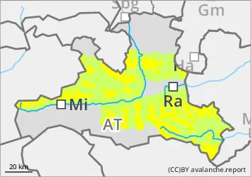
The avalanche risk is moderate above the tree line and low below. In the aspects from west to north to south-east, avalanches can easily be triggered by individuals in wind slabs. Danger areas are located behind terrain edges as well as in steep gullies and bowls, also in the forest boundary area. Avalanches can occasionally reach medium size. Above 2000 m, avalanches can still be triggered in persistent weak layers in a few places in the aspects from west to north to east and occasionally become large. Such avalanche prone locations are rare, but cannot be recognised in the terrain. Take particular care at the transitions from little to more snow.
Snowpack
Since the beginning of the week, 15 to 30 cm of new fallen snow (occasionally with graupel) has fallen, less in the Nockberge mountains. The wind (most recently mainly from the north-east to east) has been blowing in at times. New and wind slab snow is lying in shady high areas on soft, faceted snow. Away from this, the snow has fallen onto a melt-freeze crust. Deeper in the snowpack, faceted crystals can be found on a crust; close to the ground, the snowpack consists of angular, cup-shaped crystals. The connection at the transition to the deep frost near the ground is still poor.
Tendency
Light snow showers on Saturday afternoon/evening do not change the situation significantly.
The avalanche risk increases with altitude and is moderate above the tree line. The fresh wind slab can easily be triggered by individuals, in particular in the aspects from west to north to east, in high alpine areas partly also in southern aspects. Danger areas are located behind terrain edges as well as in steep gullies and bowls and in the forest boundary area. Avalanches can reach medium size and occasionally become large if they tear through the persistent weak layer.
Above 2000 m, in aspects from west to north to east, medium and occasionally large, dry slab avalanches can be triggered in persistent weak layers in a few places. Although such avalanche prone locations are rare, they are not recognisable in the terrain. Take particular care at the transitions from little to more snow.
Snowpack
At the beginning of the week, 30 to 50 cm of new fallen snow (occasionally with graupel) fell under the influence of variable, sometimes strong winds. New and wind slab snow is lying on soft, faceted snow in shady high altitudes and above around 2800 metres on sunny slopes. Away from this, the snow has fallen on a melt-freeze crust. Deeper in the snowpack, faceted crystals can be found on a crust; close to the ground, the snowpack consists of angular, cup-shaped crystals. The connection at the transition to the deep frost near the ground is still poor.
Tendency
Light snow showers on Saturday afternoon/evening do not change the situation significantly.
Danger level
treeline
Avalanche Problem
Wind slab
Treeline
Mostly favourable conditions with little snow
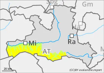
The avalanche risk is low. Above the tree line, mainly small slab avalanches can be triggered in places in the shady steep terrain adjacent to ridgelines due to low additional loads. In addition, in the entrance areas of steep gullies on shady slopes, snow slabs can occasionally be triggered in persistent weak layers. Be careful in the area of terrain traps, where the triggering of a small avalanche can have major consequences.
Snowpack
The connection between new and windslab snow and the well-settled old snowpack is usually good. However, weak layers of overblown new fallen snow near the surface can be encountered on a small scale. In the higher on shady slopes, there are still weak layers of large faceted crystals in the lower part of the snowpack, especially near the ground. Low and sunny mid-altitude areas were largely snowed out before the snowfall.
Tendency
Light snow showers on Saturday afternoon/evening do not change the situation significantly.