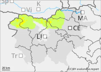
Snowfall in the mountains ranged from 5 to 10 cm, and locally in the Kamnik-Savinja Alps a little more. It will snow again on Wednesday morning and into the morning. Snowfall is expected to range from 5 cm to 1 cm. Slightly more - up to 20 cm in the Savinja Alps and eastern Karavanke. At the same time, north to north-easterly winds are picking up, bringing fresh snow and building up new snow layers in the south and west. The new fallen snow is less able to adhere to the older snow base. The danger is higher especially on slopes and in gullies where the height of the New fallen snow is greater due to the snow layering.
In addition to new fallen snow, weak layers in the snowpack deeper in the snowpack are a problem. These weak layers are more numerous in the axis above the forest. In particular, a large avalanche can be triggered if the load exceeds the load-bearing capacity of these layers.
Snowpack
dp.6: cold, loose snow and wind
As the weather cooled, the older snow base froze. Dry and light snow has fallen on harder ground and is now carried by the wind. During the snowfall, the local fall of Graupel may also have provided a new weak layer.
In the old snow cover, the layers of snow are mostly well connected, with a Crust on top, which mostly supports the skier's weight. Deep below the surface, several weak layers of faceted snow crystals and sheared grains occur.
Tendency
Thursday will be clear at first, with variable cloud formation during the day. Some peaks will be occasionally cloudy. Winds will weaken slightly. Avalanche danger will remain similar.