Weak layers in persistent weak layer remain the main danger, beware of fresh snowdrift accumulations
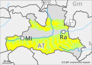
The avalanche risk is moderate above around 2000 metres and low below that. In the aspects from west to north to east, medium and occasionally large, dry slab avalanches can still be triggered by individuals in a few places. Such avalanche prone locations are rare but often not recognisable in the terrain. Take particular care at the transitions from little to more snow. In addition, fresh snowdrift accumulations form in the aspects from north-west to south-east, which can easily be temporarily disturbed by individuals. Danger areas are usually adjacent to ridgelines, behind terrain edges and in the entrance areas to steep gullies and bowls.
In sunny conditions, small loose snow avalanches can detach from extremely steep sunny slopes.
Snowpack
Between 5 and 15 cm of new fallen snow has accumulated over the past few days, including the coming night into Monday. New and wind slab snow lies in shady high areas on a soft, faceted snow surface. Otherwise, there is often an equally thin, non-load-bearing melt-freeze crust under the thin layer of fresh snow. Underneath this is a well-set sequence of compact, older drift snow layers, in which a crust is embedded in combination with faceted crystals. The connection at the transition to the old snow foundation, which consists mainly of deep rime, is still poor. Deep and sunny middle layers are largely snowed out.
Tendency
With some snowfall and wind in the night to Tuesday, the avalanche prone locations due to wind slab will increase slightly and the risk of avalanches will rise slightly.
Danger level
1800m
Avalanche Problem
Persistent weak layer
1800m
Take into account persistent weak layers and avoid small-scale pillows of wind drifted snow
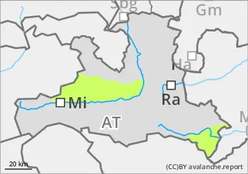
The avalanche risk is low. Medium-sized slab avalanches can still be triggered in a few hard-to-recognise places, especially in the extended northern sector above 1800 m, but usually only with a large additional load. This is in particular at the transitions from little to more snow. Fresh, small-scale pillows of wind drifted snow in the areas adjacent to the ridgeline, crest or summit of the extended northern and eastern exposures are temporarily prone to triggering.
Snowpack
Once again, it is snowing unproductively. The little new and wind slab snow lies in shady high areas on a soft, faceted snow surface. Otherwise, there is often an equally thin, non-load-bearing melt-free crust under the thin layer of fresh snow. Underneath this is a well-set sequence of compact, older drift snow layers, in which a crust is embedded in combination with faceted crystals. The connection at the transition to the old snow foundation, which consists mainly of deep rime, is still poor. Deep and sunny middle layers are largely snowed out.
Tendency
With a brisk westerly wind, it will snow unproductively on Monday, the avalanche danger will not change significantly.
Danger level
Low risk of isolated wet snow avalanches
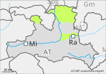
The avalanche risk is low. In the entrance areas of steep gullies on the shady slopes, small snow slabs can still be triggered in exceptional cases with a large additional load. The risk of being swept away and falling on icy surfaces that may be thinly covered with snow and therefore difficult to recognise generally outweighs the risk of burial.
Snowpack
It snows unproductively during the night. Low and sunny mid-altitude areas are snowed out. Where present, the snowpack is moist to wet and well-set right up to the summit areas. Due to the many clouds, the snow surface can hardly outgoing longwave radiation overnight, no stable melt-freeze crust forms. In the higher areas on shady slopes, there are still weak layers of large faceted crystals in the lower part of the snowpack, especially near the ground.
Tendency
With some snowfall and wind, small-scale avalanche prone locations will develop in the night to Tuesday due to fresh wind slab and the avalanche risk will increase slightly.