Weak persistent layers become even easier to disturb during daytime changes
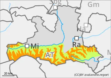
The avalanche risk is considerable from around 2000 m, below that it is low. In some places, medium to large slab avalanches can be triggered by individuals, especially in the north-west to east aspects. Take particular care at the transitions from little to more snow. Danger areas are often difficult to recognise and a defensive choice of route is still advised. As the snowpack softens during daytime changes, deeper layers can be disturbed much more easily. Occasionally, wet snow slabs are then also possible in sunny slopes that have not yet been unloaded.
Snowpack
The snowpack can cool down well overnight and form a melt-freeze crust, which softens again during the day on sunny slopes. In general, the snowpack on sunny slopes is damp or wet up to high altitudes. In shady high altitudes, some of the snow surface is still soft, faceted snow, some of which has already crusted can form. Below this lies a now well-set and connected sequence of compact drift snow layers, but often a crust with angular crystals is still embedded in the upper area. The connection at the transition to the old snow foundation, which consists mainly of deep rime, is still poor to very poor and fractures can still be easily provoked here. Deep and sunny middle layers are often already snowed out.
Tendency
The number of avalanche prone locations in the persistent weak layer is only slowly decreasing. The outgoing longwave radiation is somewhat limited on Sunday night.
Danger level
2000m
Avalanche Problem
Persistent weak layer
2000m
Weak persistent layers become even easier to disturb during daytime changes
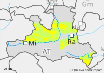
The avalanche risk is moderate above the tree line and low below. In a few places that are often difficult to recognise, medium-sized slab avalanches can still be triggered by individuals, especially in the extended northern sector. This is in particular at the transitions from little to more snow. As the snowpack softens during daytime changes, deeper layers can be disturbed much more easily. Occasional wet snow slabs are then also possible in sunny slopes that have not yet been unloaded.
Snowpack
The snowpack can cool down well overnight and form a melt-freeze crust, which softens again during the day on sunny slopes. In general, the snowpack on sunny slopes is damp or wet up to high altitudes. In shady high altitudes, some of the snow surface is still soft, faceted snow, some of which has already crusted can form. Below this lies a now well-set and connected sequence of compact drift snow layers, but often a crust with angular crystals is still embedded in the upper area. The connection at the transition to the old snow foundation, which consists mainly of deep rime, is still poor to very poor and fractures can still be easily provoked here. Deep and sunny middle layers are often already snowed out.
Tendency
The number of avalanche prone locations in the persistent weak layer is only slowly decreasing. The outgoing longwave radiation is somewhat limited on Sunday night.
Danger level
Avalanche Problem
Wet snow
Low risk of isolated wet snow avalanches
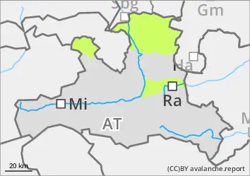
The avalanche risk is low. Small spontaneous wet snow avalanches are still possible in the afternoon on the few sunny slopes that have not yet been discharged. In addition, small snow slabs can still be triggered occasionally in the entrance areas of gullies and bowls on the shady slopes, but usually only with a large additional load.
Snowpack
The snowpack is moist to wet and well settled right up to the summit areas. The snow surface can cool down well overnight and crust can form, but on the sunny slopes it softens again during the day. In the higher on shady slopes, there are still weak layers of large faceted crystals in the lower part of the snowpack, especially near the ground. Low and sunny mid-altitude areas are snowed out.
Tendency
No change in avalanche danger. Weak daytime changes in wet snow avalanche activity.