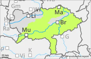
Danger level
 | 1800m |
|  |
|  | ||||
|  |  |


![]()
Persistent weak layer problem in shady high altitudes!
The avalanche danger is rated as moderate above 1800 metres. Wet loose snow avalanches from slopes that have not yet been discharged are still possible. The frequency of final loads has decreased. There is still a persistent weak layer problem in the northern sector: Triggering of dry slab avalanches is possible in very steep gullies and bowls on shady slopes with large additional loads. The avalanches can tear through to the ground in the northern sector.
Snowpack
The firmness of the snowpack surface increases again briefly during the night. The expected new fallen snow is not relevant for avalanches. On the northern slopes, the kinetic metamorphism (cup crystals in the snow layer close to the ground!) continues to weaken the snowpack.
Tendency
We will remain under the influence of weak disturbances on Tuesday and Wednesday. There will be an increased risk of showers in the afternoon, especially from the Gurktal Alps to the Eisenerz Alps, with the possibility of a few centimetres of new fallen snow. However, only above 1600 metres, as the temperature level will remain high. No significant change in the avalanche risk is expected.