As the weather warms up, the danger of wet snow avalanches has increased. Blowing snow in the high alpine regions!
The main danger will be wet snow avalanches and gliding avalanches. As the weather warms up during the day, the danger of triggering, especially on sunny slopes, will increase significantly.
However, there are still many places in the high alpine regions with blown snow where a small load can trigger a major avalanche. Weak layers in the snowpack are also a problem. If the load exceeds the load-bearing capacity of the deeper Weak layers, a deep and large avalanche can be triggered. There are many such weak layers, especially on axis above the forest.
Snowpack
dp.1: deep persistent weak layer dp.10: springtime scenario
The old snow cover is made up of layers of bonded snow that are already somewhat compacted, and which are mostly well connected to each other. Deep below the surface, several weak layers of faceted snow crystals and coarse grains occur in the old snow cover.
This base was covered by 50 to 80 cm of new fallen snow during the last snowfall in the high alpine regions, which has already begun to settle to some extent. The warmer temperatures and sunshine have led to the formation of a more or less distinct Crust. The snow is drying out during the day and freezing at night. The snowpack is also melting in the mid-mountains.
Tendency
The weather will continue to be quite clear and warm. Typical spring conditions are expected over the next few days. The snowpack will frost overnight in very dry conditions and will become much thinner during the day, due to the influence of the sun, up to the highest peaks.
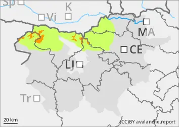
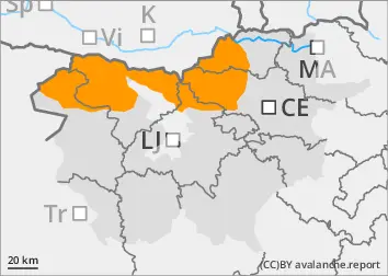
Danger level
1300m
Avalanche Problem
Wet snow
1300m
Gliding snow
1300m
Minor wet snow avalanches possible due to thawing
The snowpack of the last snowfall has become unstable as the weather warms up. The danger of wet snow avalanches has increased, especially on extreme terrain. On grassy slopes, gliding avalanches will be possible. This only applies to the highest peaks where there is some more snow.
Snowpack
dp.4: cold following warm / warm following cold
As the weather warms up, much of the snow from the last snowfall has been cleared away. The snow line is at around 1200 m. At higher altitudes, the snow of the last snowfall has become much heavier and is being transformed more quickly.
Tendency
Typical spring conditions are expected over the next few days.
The snowpack will freeze overnight, but during the day, with sunshine and high temperatures, the snow will change and melt more quickly.
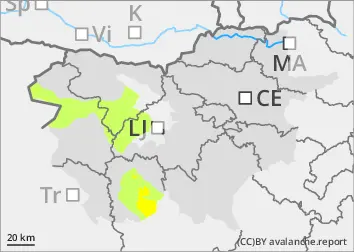
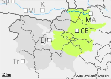
Danger level
800m
Avalanche Problem
Wet snow
800m
Wet snow avalanche possible due to thawing
The snowpack of the last snowfall has become unstable as it warms up. The danger of wet snow avalanches has increased, especially on extreme terrain. On grassy slopes, gliding avalanches will be possible.
Snowpack
dp.4: cold following warm / warm following cold
As the weather warms up, the snowpack from the last snowfall is rapidly melting.
Tendency
Typical spring conditions are expected over the next few days.
The snowpack will freeze overnight, but during the day, with sunshine and high temperatures, the snow will change and melt more quickly.