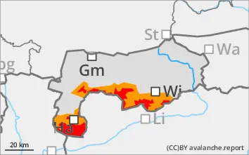
Avalanche prone locations due to easily triggered wind slabs and naturally triggered avalanches!
The avalanche danger is mainly categorised as considerable, in the higher altitudes partly still as high. Fresh, extensive and older snowdrift accumulations are prone to triggering. The triggering of slab avalanches is possible even with low additional loads. There are avalanche prone locations in steep terrain, in all aspects, adjacent to ridgelines as well as distant from ridgelines at terrain transitions and in transition areas from more to less snow. With the strong incoming radiation and the marked warming during the daytime changes, spontaneous slab avalanches, including wet snow avalanches, are to be expected at higher elevations. In general, avalanches can be medium to large.
Snowpack
There was a large increase in fresh snow on Tuesday. Depending on the region and altitude, there were 30 to 50 and locally even more. Stormy winds caused extensive drifting. The snowfall level was between 1000 and 1400 metres. The extensive drift snow packs of the last few days contain weak layers and lie on a weak foundation. At low and medium elevations, the snowpack is moist to wet. At higher elevations, the snowpack is beginning to settle with the rapid rise in temperatures and is becoming increasingly wet and heavy.
Tendency
Gradual decrease in avalanche danger in the coming days.
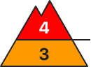
Danger level
1800m
Avalanche Problem
Wind slab
1800m
Wet snow
1800m
Considerable avalanche danger!
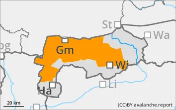
The avalanche risk is predominantly categorised as considerable. Fresh, extensive and older snowdrift accumulations are prone to triggering. The triggering of slab avalanches is possible even with low additional loads. There are avalanche prone locations in steep terrain, in all aspects, adjacent to ridgelines as well as distant from ridgelines at terrain transitions and in transition areas from more to less snow. With the strong warming during the daytime changes, spontaneous slab avalanches, including wet snow avalanches, are to be expected at higher elevations. In general, avalanches will be medium to rare in size.
Snowpack
There was a large increase in fresh snow on Tuesday. Depending on the region and altitude, there were 30 to 50 and locally even more. Stormy winds caused extensive drifting. The snowfall level was between 1000 and 1400 metres. The extensive drift snow packs of the last few days contain weak layers and lie on a weak foundation. At low and medium elevations, the snowpack is moist to wet. At higher elevations, the snowpack is beginning to settle with the rapid rise in temperatures and is becoming increasingly wet and heavy.
Tendency
The avalanche danger will slowly decrease over the next few days.