Highly prone to triggering wind slab snow at the top, spontaneous wet snow avalanches at the bottom
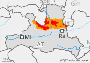
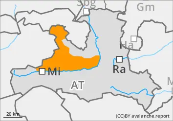
The avalanche risk is high above the tree line (level 4) and considerable below. Individual naturally triggered avalanches are still possible and in many places medium and sometimes large slab avalanches can easily be triggered by individuals (even from a distance). All aspects are affected, but increasingly north and east-facing steep terrain. Danger areas are not easy to recognise everywhere, which is why caution and a defensive choice of route is still advised. This applies in particular in the area of the tree line and in forest aisles. Wet loose snow and gliding avalanches are possible at low and medium altitudes due to heavy rainfall. These usually remain medium-sized, but occasionally the entire snowpack can slide off on very steep, unstructured terrain.
Snowpack
Up to half a metre of fresh new or wind slab snow lies on top of several more thick layers of wind-blown new fallen snow from the last few days. Especially at the beginning, snow fell with less wind and at colder temperatures, which is why soft layers are also embedded. These overlay somewhat older wind slab snow, which in turn lies on an unfavourable base of faceted crystals and deep rime. In wind-protected areas, some surface hoar has also been snowed in. Up to around 1800 metres, the snowpack was soaked by heavy rain. Fractures primarily occur between the last snow packs, but can also penetrate through to the old snow foundation, which is usually completely transformed. At low and medium altitudes, heat and rainfall put a strain on the snowpack.
Tendency
Precipitation will set in again, with rain falling at times up to around 2000 metres on Tuesday. Above that, 20 to 40 cm will fall. The avalanche situation remains tense.
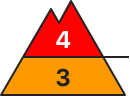
Danger level
treeline
Avalanche Problem
Wind slab
Treeline
Persistent weak layer
Treeline
Wet snow
1800m
High prone to triggering in wind slabs
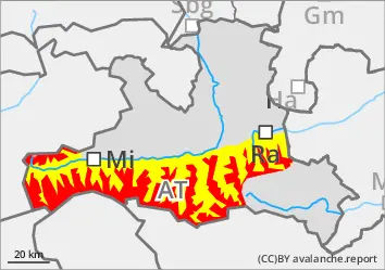
The avalanche risk is high above the tree line (level 4) and moderate below. Individual naturally triggered avalanches are still possible and in many places medium and sometimes large slab avalanches can easily be triggered by individuals (even from a distance). All aspects are affected, but increasingly north and east-facing steep terrain. Danger areas are not easy to recognise everywhere, which is why caution and a defensive choice of route is still advised. This applies in particular in the area of the tree line and in forest aisles. Wet loose snow and gliding avalanches are possible at low and medium altitudes. These usually remain medium-sized at most, but occasionally the entire snowpack can slide off on very steep, unstructured terrain.
Snowpack
Up to half a metre of fresh new or wind slab snow lies on top of several more thick layers of wind-blown new fallen snow from the last few days. Especially at the beginning, snow fell with less wind and at colder temperatures, which is why soft layers are also embedded. These overlay somewhat older wind slab snow, which in turn lies on an unfavourable base of faceted crystals and deep rime. In wind-protected areas, some surface hoar has also been snowed in. Up to around 1800 metres, the snowpack was at least superficially moistened. Fractures primarily occur between the last snow packs, but can also penetrate through to the old snow foundation, which is usually completely transformed. At low and medium altitudes, heat and rainfall put a strain on the snowpack.
Tendency
Precipitation will set in again, with rain falling at times up to around 2000 metres on Tuesday. Above that, 20 to 40 cm will fall. The avalanche situation remains tense.
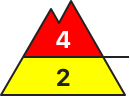
Danger level
treeline
Avalanche Problem
Wind slab
Treeline
Persistent weak layer
Treeline
Wet snow
1800m
Prone to triggering wind slab snow at the top, spontaneous wet snow avalanches at the bottom
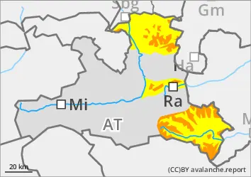
The avalanche risk is considerable. At low and medium altitudes, warmth and heavy rainfall put a strain on the snowpack, while fresh wind slab is formed at higher altitudes. Medium to large slab avalanches can be triggered in some places by a single person. Danger areas are located at the transition from little to more snow and generally next to blown-off areas as well as in the entrance areas to gullies and bowls filled with wind slabs. Caution should also be exercised at the edge of forests and in forest aisles. At low and medium elevations, medium wet loose snow and gliding avalanches are also to be expected.
Snowpack
Rainfall has soaked the snowpack up to altitudes of around 1800 metres. At high altitudes, the new snow cover is inhomogeneous and prone to triggering (harder layers alternate with softer ones) due to repeated wind influences of varying intensity. Where present, the old snow foundation has been completely transformed. Fractures are possible mainly between the last layers of drift snow, but under greater stress, deep-lying faceted layers in the persistent weak layer or the coarse-grained base of deep rime are also affected.
Tendency
Heavy precipitation sets in again, with intense rain at times up to around 2000 metres on Tuesday. Above that, there is heavy new fallen snow of 30 to 60 cm (mainly Steinberge/Hochkönig/Tennengebirge). The avalanche situation worsens again.
Danger level
treeline
Avalanche Problem
Wind slab
Treeline
Persistent weak layer
Treeline
Wet snow
1800m
Highly prone to triggering windslab snow on poor old snowpack
The avalanche risk is considerable from the tree line upwards and moderate below. At low and medium altitudes, warmth and rainfall put a strain on the snowpack, while fresh wind slab is formed at higher altitudes. Medium to large slab avalanches can be triggered by individuals in some places. Danger areas are located at the transition from little to more snow and generally next to blown-off areas as well as in the entrance areas to gullies and bowls filled with wind slabs. Caution should also be exercised at the edge of forests and in forest aisles. At low and medium elevations, small, wet loose snow and gliding avalanches are to be expected.
Snowpack
Rainfall has moistened the snowpack at least on the surface up to altitudes of around 2000 metres, and at lower altitudes it is sometimes wet right down to the ground. At high altitudes, the new snow cover is inhomogeneous and prone to triggering (harder layers alternate with softer ones) due to repeated wind influences of varying intensity. Where present, the old snow foundation has been completely transformed. Fractures are possible mainly between the last layers of drifting snow, but deeper-lying faceted layers in the persistent weak layer or the coarse-grained base of deep rime are also affected.
Tendency
Heavy precipitation sets in again, with intense rain at times up to around 2000 metres on Tuesday. Above that, there is heavy new fallen snow of 30 to 60 cm (mainly Steinberge/Hochkönig/Tennengebirge). The avalanche situation worsens again.