The current snowpack pattern is uncommon and requires special attention and caution!
New fallen snow in the high alpine regions, weak layers persist.
In particular, even a small additional load can trigger a small avalanche on snowdrift accumulations. A triggered avalanche or an otherwise large Additional load may exceed the load-bearing capacity of the deep hard layers, triggering a deep and widespread (large) avalanche. Such weak layers are particularly abundant in the axis above the forest, but are not excluded elsewhere. Gliding avalanches also occur on steep smooth slopes.
Snowpack
dp.1: deep persistent weak layer dp.4: cold following warm / warm following cold
Snow has melted on the highest peaks of the sunny slopes in recent days, while only the high alpine regions have remained dry. Up to 10 cm of new fallen snow has fallen since Tuesday afternoon, and up to 30 cm in the Southern Julian Alps. The snowfall level was around 1300 m most of the time, rising to 1700 m towards the end of the precipitation. The snowpack is thinned to around 1700 m due to the rain, and a Crust will form as it cools.
The old snow cover is made up of layers of bonded snow that are already somewhat compacted and mostly well interconnected. The cohesion of the layers of blown snow in snowdrift accumulations built up by the southerly wind during the snowfall is weaker. In the old snow cover, there are several weak layers of shreds and sheared grains deep below the surface.
Tendency
The avalanche danger will remain similar until the end of the week. There will be a little more New fallen snow on Thursday and sunny skies on Friday.
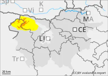
Danger level
1800m
Avalanche Problem
Wind slab
1800m
Persistent weak layer
1800m
New snow
Treeline
The current snowpack pattern is uncommon and requires special attention and caution!
New fallen snow in the high alpine regions, weak layers persist.
In particular, even a small additional load can trigger a small avalanche on snowdrift accumulations. A triggered avalanche or an otherwise large Additional load may exceed the load-bearing capacity of the deep hard layers, triggering a deep and widespread (large) avalanche. Such weak layers are particularly abundant in the axis above the forest, but are not excluded elsewhere. Gliding avalanches also occur on steep smooth slopes.
Snowpack
dp.1: deep persistent weak layer dp.4: cold following warm / warm following cold
Snow has melted on the highest peaks of the sunny slopes in recent days, while only the high alpine regions have remained dry. Up to 10 cm of new fallen snow has fallen since Tuesday afternoon. The snowfall level was around 1300 m most of the time, rising to 1700 m towards the end of the precipitation. The surface of the snowpack has been thinned by the rain up to about 1700 m, and a Crust will form as it cools.
The old snow cover is made up of layers of bonded snow that are already somewhat compacted and mostly well interconnected. The layers of blown snow in snowdrift accumulations built up by southerly winds during the snowfall are less well connected. In the old snow cover, there are several weak layers of shreds and faceted snow crystals deep below the surface.
Tendency
The avalanche danger will remain similar until the end of the week. There will be a little more New fallen snow on Thursday and sunny skies on Friday.
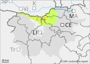
Danger level
1200m
Avalanche Problem
Gliding snow
1200m
New snow
Treeline
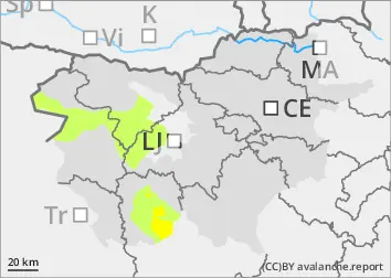
Increased amount of new snow in the highest parts of the mid-mountains, snowdrift accumulations
Blowing snow, gliding avalanches.
In particular, even a small additional load can trigger a small avalanche on snowdrift accumulations. Gliding avalanches also occur on steep, smooth slopes.
Snowpack
Up to 30 cm of New fallen snow fell above 1200 m. New fallen snow fell on an almost level surface. The old snow cover is made up of layers of bonded snow that are already somewhat compacted. A depth hoar has formed at the interface between the snowpack and the ground.
Tendency
The avalanche danger will remain similar until the end of the week. Saturday will be cloudy with showers. Sunday will be sunny and windy.