The current snowpack pattern is uncommon and requires special attention and caution!
New and blown snow in the high alpine regions.
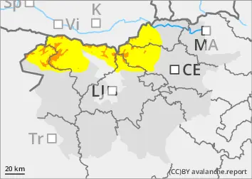
In the mountains, the last snow episode saw a significant amount of new snow. Wetter snow fell below about 1800 m, while lower down it snowed partly and rained partly. More dangerous are places where southerly winds have built up large snow drifts. In these places, even a light load can trigger snowdrifts. In shaded areas, there is a weak layer deep in the snowpack which can be a danger, especially on the axial sides.
Snowpack
dp.1: deep persistent weak layer dp.4: cold following warm / warm following cold
The last two-day snow episode saw a lot of New fallen snow in the high alpine regions, with a little more snow over the weekend. Below about 1800 m, the snow is moist and well bonded throughout the snowpack. Higher up, the snow is drier and lighter. South winds have built up new large drifts on the leeward sides of the ridges. There is a weak layer deep below the surface in the old snow cover, which can be a problem in high alpine regions on the axial sides.
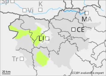
The snowpack in the high alpine regions is only slowly transforming, it has transformed somewhat more in the mid-mountains.
Tendency
Mostly cloudy weather will continue early in the week, with occasional showers, with high alpine regions occasionally rising above the cloud layer.
Danger level
Avalanche Problem
New snow
Increased amount of new snow in the highest parts of the mid-mountains, snowdrift accumulations
More new fallen snow in the highest parts of the Central Mountains
In the mountains, the last two-day snow episode has seen a significant amount of new snow above about 1500 m. Lower down, it snowed partly (wetter snow) and rained partly. South and south-easterly winds built up snow drifts on ridges and peaks.
Snowpack
The old snow cover, which was mostly sparse, received 50-60 cm of new fallen snow above an altitude of around 1500 m, and more locally, especially in the south of the country. The snow is moist throughout the snowpack and is already fairly well bonded to each other. Winds from the south and south-east have built up on the leeward sides of the ridges.
Tendency
Mostly cloudy weather will continue at the start of the week, with occasional showers.