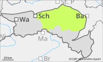
Danger level
 | 1500m |
|  |
|  |

![]()
Low avalanche danger, but watch out for older wind slabs in the north and east aspects!
The avalanche risk is low. In a few places, snowdrift accumulations can be triggered as small slab avalanches, especially in extremely steep and shady gullies and bowls. Avalanche prone locations and icy areas are covered with a thin layer of fresh snow. The risk of falling and injury is greater than the danger of burial.
Snowpack
There is still significantly less snow than average. From midday, a few centimetres of new fallen snow may cover small, older snowdrift accumulations. Where there is a snow base, fundament (shady areas at high altitudes), angular snow crystals will weaken the stability of the snowpack.
Tendency
Wednesday will bring lots of clouds, it will become milder and it will slowly start to rain or snow at the highest altitudes. The precipitation intensifies towards the evening and the snowfall level slowly drops. The avalanche risk will remain low on Wednesday, but may increase afterwards depending on the amount of new snow.