Danger level
 | treeline |
|  |
|  | ||||
| |
|  |


![]()
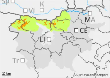
The current snowpack pattern is uncommon and requires special attention and caution!
In high alpine regions, weak layers in the snowpack, blowing snow
The new fallen snow has put additional stress on the weak layers in the old snow cover. Places with blown snow and shady areas where there is a weak layer deep in the snowpack are more dangerous. In particular, at low loads, medium-sized avalanches of packed snow will be possible. In the mid-mountains, the new fallen snow has already transformed somewhat and adhered better to the ground.
Snowpack
dp.1: deep persistent weak layer
The weak snowpack has been followed by more snow in the last week or so. The new fallen snow has adhered slightly better to the ground in the central mountains, where rain or wet snow has fallen in between. On sunny slopes, a crust has formed in some places and some dry and light snow has fallen on it. The danger of avalanches is higher, especially in the shaded areas of the high alpine regions and in places where wind has built up drifts. Deep and persistent weak layers are present in the old snow cover. The snowpack is unstable in many places.
Tendency
On Tuesday, it will become cloudy again. Moderate precipitation will begin to fall. The snowfall level will rise, with snow in the afternoon at altitudes between 1000 and 1600 m, lower in the eastern Julian Mountains. A strong south-westerly wind will blow, carrying large amounts of snow. The danger of avalanches will increase.