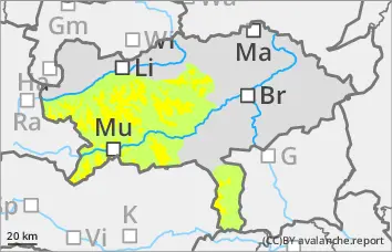
The avalanche risk is still rated as moderate above 1,800 metres and low below that. Older snowdrift accumulations can be triggered as slab avalanches in a few places even with little additional load and can also reach medium size when breaking through into the persistent weak layer. The danger areas are located in the north to east aspects behind ridgelines and terrain edges as well as in the entrance areas to steep gullies and bowls.
Snowpack
Sun and slight warming lead to a settlement of the snowpack. On the northern sides, a layer of snow covers surface hoar and older wind slab in the higher elevations. In the northern and eastern exposures, the snowpack is still weakened with faceted crystals and floating snow (persistent weak layer problem!).
Tendency
On Friday, the sun will shine at times, especially in the west of Upper Styria, while clouds will predominate in the eastern half of the country. No change in the avalanche risk is expected.
Danger level
Avalanche Problem
Persistent weak layer
Persistent weak layer problem in the northern sector!
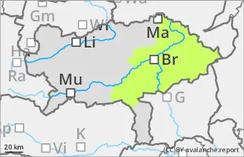
The avalanche danger is assessed as low. The main issue is the persistent weak layer problem. New fallen snow (approx. 10cm) covers the avalanche prone locations. Poor visibility means that the avalanche danger can only be assessed to a limited extent. The few avalanche prone locations are in the northern sector. Snow slabs can be triggered here if there is a large additional load.
Snowpack
Some new fallen snow covers the partly hard old snowpack. On the north side, the old snowpack has also been transformed. The old snowpack is weakened by the kinetic metamorphism (angular shapes). Still little snow.
Tendency
No change in the avalanche danger is expected.
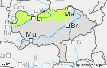
Danger level
treeline
Avalanche Problem
Wind slab
Treeline
Low avalanche danger.
The avalanche risk is low. In extremely steep gullies and on shady slopes above the tree line, the triggering of small slab avalanches cannot be completely ruled out. Fresh pillows of wind drifted snow can be triggered as small avalanches behind ridges.
Snowpack
In the last 24 hours, fresh wind slab snow (approx. 10 to 15 cm) has been deposited on a crusted can form old snowpack. Angular shapes weaken the snow layering.
Tendency
The Adriatic low will bring about 10 cm of new fallen snow overnight. No significant change in the avalanche risk is expected.