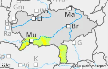
The avalanche danger is rated as moderate above the tree line and low below. The main problem is wind slab. The avalanche prone locations are in the terrain adjacent to ridgelines and in the entrance areas of gullies and bowls. The northern sector is particularly affected. Triggering of a snow slab is possible with a small additional load. The slab can slide to the bottom, so medium avalanches cannot be ruled out.
Snowpack
On Sunday, 10 to 25 cm of new snow will fall with wind on a crust can form and hardness with partial surface hoar. The connection between the fresh wind slab and the old snowpack will not be sufficient. The snow base, fundamentally set and compact. In extremely steep gullies on shady slopes, the snow base, fundament is partly weakened by angular shapes.
Tendency
On Monday morning, residual clouds and the last showers, increasingly sunny during the day. Sunny weather on Tuesday under the influence of intermediate highs. No significant change in the avalanche danger is expected.
Danger level
1800m
Avalanche Problem
Persistent weak layer
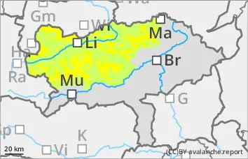
1800m
Persistent weak layer problem in northern and eastern aspects!
The avalanche risk is assessed as moderate above 1,800 metres and low below that. Slab avalanches can be triggered in some places even with little additional load and can reach medium size when breaking through the persistent weak layer. The danger areas are still located in the north to east aspects behind ridgelines and terrain edges as well as in the entrance areas to steep gullies and bowls.
Snowpack
Some new or drift snow covers surface hoar and, at higher altitudes, older drift snow in the northern and eastern exposures on an unstable snowpack with weak layers of faceted crystals and floating snow. The connection between the wind slab and the old snowpack will not be sufficient. On the sunny slopes, the old snowpack is mostly settled and quite compact.
Tendency
On Monday morning, residual clouds and the last showers, increasingly sunny during the day. Sunny weather on Tuesday under the influence of intermediate highs. No significant change in the avalanche danger is expected.
Danger level
Avalanche Problem
Persistent weak layer
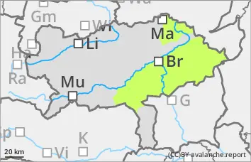
Low avalanche danger, isolated avalanche prone locations on shady slopes!
The avalanche risk is low. In extremely steep gullies and on shady slopes above the tree line, the triggering of small slab avalanches cannot be completely ruled out. Avalanche prone locations may be difficult to recognise due to poor visibility and a thin covering of soft new fallen snow.
Snowpack
Some new fallen snow is deposited on a crusted can form. Angular shapes weaken the snow layering. Some grassy slopes are snowed in again.
Tendency
On Monday morning, residual clouds and the last showers, increasingly sunny during the day. Sunny weather on Tuesday under the influence of intermediate highs. No significant change in the avalanche danger is expected.