Danger level
 |

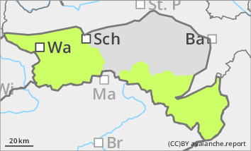
Low avalanche danger with little snow. Beware of the risk of falling!
The avalanche risk is low. With below-average snow conditions, there are only a few avalanche prone locations, which are limited to the extremely steep slopes of the northern exposures. At higher altitudes, the snowpack is often hard and icy due to the wind and melting. Avalanche prone locations and icy areas may be covered by a thin layer of fresh snow or thin pillows of wind drifted snow on Sunday. Beware of the risk of falling in sometimes poor visibility!
Snowpack
The snowpack is well below average for the time of year. In sunny slopes, it is mostly bare beyond the tree line. On shady slopes, the thin snow surface is crusted can form and hard, sometimes icy. At higher altitudes it is mostly blown off, only in wind-protected areas is there a little more snow. In extremely steep gullies on shady slopes, angular shapes can weaken the snow base, fundament. Above this, however, there is usually only a little snow. Thin pillows of wind drifted snow form above 1500 metres due to new fallen snow and wind.
Tendency
The avalanche danger remains the same. During the night to Monday, the precipitation will decrease rapidly and the wind will weaken considerably. Monday will be mostly cloudy and free of precipitation. On Tuesday, sunny weather will prevail again. Slightly cooler than recently with temperatures at 1500 metres around -3 degrees.