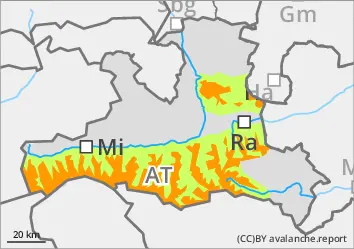
The risk of avalanches increases rapidly with altitude from around 1800 metres and is considerable above 2000 metres.
Slab avalanches can be triggered in some places by small additional loads and can reach medium size. Avalanche prone locations are concentrated in the north-west, north to east facing steep terrain, but also in the southern sector, behind terrain edges and in gullies and bowls. They increase rapidly in size and frequency with altitude. The wind slabs are often located directly next to blown-off areas, are easily recognisable and should be avoided at all costs. Cracks and whumpfing collapsing sounds when walking on the snow cover, snowpack are a sign of danger.
Snowpack
Under the influence of mild air and sunlight, the snow cover, snowpack has settled and become cardboardy up to around 2000 metres. It has at least a thin melt-freeze crust in the morning. Fresh and older wind slabs lie on an angular, prone-to-triggering old snow base. Further weak layers of faceted crystals and deep rime lie in the persistent weak layer below and can occasionally be activated by surface avalanches. The total snow depth is still well below average in many places. Broad ridge and ridges are often completely blown off.
Tendency
No significant change on Monday, the foehn will continue, wind slab problem persists.
Danger level
2000m
Avalanche Problem
Wind slab
2000m
Consistently avoid drifting snow areas
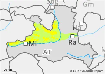
The avalanche danger is moderate above 2000 metres and low below. Small to medium slab avalanches can be triggered in very steep terrain by even a small additional load. Most avalanche prone locations are on north-west, north to south-east facing slopes, behind ridges and in gullies and bowls. The wind slab is easily recognisable and should be avoided. Cracks and whumpfing collapsing sounds when walking on the snow cover, snowpack indicate danger.
Snowpack
Under the influence of mild air and sunlight, the snow cover, snowpack has settled and become cardboardy up to around 2000 metres. In the morning it has at least a thin melt-freeze crust, and up to around 1900 metres it also has a crust of rain ice. At high altitudes, older wind slab snow is still prone to triggering in places, and fresh wind slab snow is also formed on a small scale during the day. The transition to the old snowpack (faceted crystals on/under the crust) usually serves as a weak layer. It consists of layers of faceted crystals, deep rime and melt-freeze crusts. Surface-triggered avalanches can tear through to the ground. The total snow depth is still well below average. Ridges and ridges are often completely blown off.
Tendency
It will remain foehn, the situation will not change significantly on Monday.
Danger level
1800m
Avalanche Problem
Wind slab
1800m
The wind slab is easily recognisable - avoid it consistently
The avalanche danger is moderate above around 1800 metres and low below.
Small to medium slab avalanches can be triggered in very steep terrain by low additional loads. Most avalanche prone locations are on north-west, north to south-east facing slopes, behind ridges and in gullies and bowls. The wind slab is easily recognisable and should be avoided.
Snowpack
Under the influence of mild air and sunlight, the snow cover, snowpack has settled and become cardboardy up to around 2000 metres. In the morning, it has a melt-freeze crust that is not stable everywhere. At higher altitudes, older wind slabs are still prone to triggering in places. The transition to the old snowpack (faceted crystals on/under the crust) usually serves as a weak layer. It consists of layers of faceted crystals, deep rime and melt-freeze crusts. The total snow depth is still well below average. Ridges and ridges are often completely blown off.
Tendency
No significant change.
Danger level
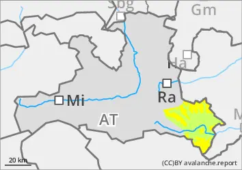
Avalanche Problem
Wet snow
Low risk of small, wet avalanches
The avalanche risk is low. Individual wet and predominantly small avalanches can spontaneously break loose from very steep terrain with the sunlight.
Snowpack
The snow cover, snowpack is moist to wet due to rainfall, mild air and sunlight, depending on the altitudes, and closes with a crust of melt or rain ice, which forms a steep sunny slope during the day. The snow base, fundament is partially weakened by persistent weak layers.
Tendency
No significant change on Sunday. A moderately strong southerly wind is not able to move the snow.