Wet snow avalanches are possible as the weather warms up, especially in the mid-mountains
The most dangerous places are those with blown snow, where a heavy load can trigger a small to medium-sized Avalanche. Greater caution is needed in ravines and gullys, where there may be large amounts of blowing snow. Individual wet snow avalanches are possible as the weather warms up, especially in the mid-mountains.
Snowpack
dp.4: cold following warm / warm following cold
The snow base is uneven due to the influence of wind. There is some light snow in the sheltered areas of the high alpine regions, but for the most part the snow base is hard and covered with a crust. Greater caution is needed, especially in places where wind has created new snow layers. The thaw has softened the snowpack in the mid-mountains.
Tendency
It will remain warm, with isolated avalanches of southern snow still possible, especially in the central mountains. Above the tree line, there will still be dangerous spots of blowing snow.
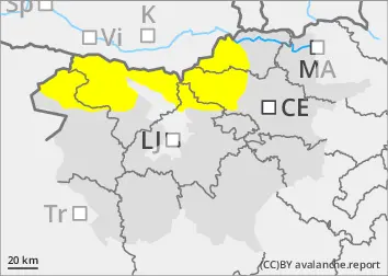
Danger level
Avalanche Problem
Wet snow
Wet snow avalanches are possible as the weather warms up, especially in the mid-mountains
Individual creeps and small wet snow avalanches are possible as the weather warms up.
Snowpack
dp.4: cold following warm / warm following cold
The warming temperatures have softened the snowpack.
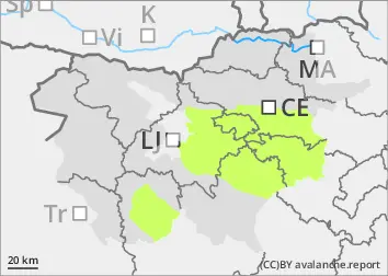
Tendency
It will stay warm, but the danger of avalanches will remain similar.