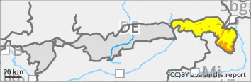
The avalanche danger is considerable. The main problem is wind slab avalanches. Slab avalanches can be triggered in blown-in areas, especially on steep slopes with aspects from north to east to south and in gullies and bowls with little additional load. Avalanche prone locations can also be found in forest transition areas as well as in clearings and forest aisles. Avalanches can become large at higher altitudes.
There is also a pronounced wet snow problem in the morning. Moist and wet loose snow and slab avalanches are released from steep areas of all aspects. Wet snow avalanches are expected up to an altitude of around 1800 metres. Exposed transportation routes may be affected.
Snowpack
The snow layering is still unfavourable. In the leeward areas of the eastern aspects and in gullies, bowls and forest gaps, there are thick drift snow packs that continue to grow with the onset of wind from south-westerly directions. They are widely lying on soft layers or surface hoar and are interspersed with weak intermediate layers. By mid-morning, the snowfall will change to rain at medium altitudes, further weakening the snow cover, snowpack. Weak layers can collapse if moisture gets in. At high altitudes, the snowpack base often consists of faceted crystals.
Tendency
The risk of avalanches will decrease over the next few days with warmer temperatures.
EARLIER Danger level
treeline
Avalanche Problem
Wind slab
Treeline
New snow
LATER Danger level
treeline
Avalanche Problem
Wind slab
Treeline
Wet snow
1700m
Many wet snow avalanches are expected during the daytime changes
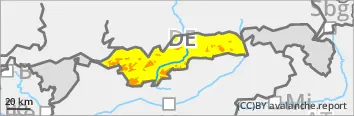
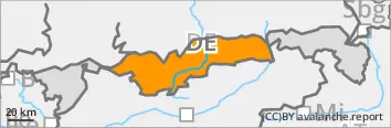
The avalanche danger is considerable above the tree line. Below this, it increases from moderate to considerable over the course of the daytime changes. The main problem is wind slab avalanches. Slab avalanches can be triggered in blown-in areas, especially on steep slopes with aspects from north to east to south and in gullies and bowls with little additional load. Avalanche prone locations can be found at all altitudes, including in forest transition areas as well as in forest aisles and clearings. Avalanches reach medium size.
In addition, the previous new snow problem will turn into a wet snow problem in the late morning. Medium-sized loose snow and slab avalanches can be triggered with little additional load. Later on, naturally triggered avalanches are to be expected from steep areas of all aspects up to an altitude of approx. 1700 metres.
Snowpack
In the leeward areas of the eastern aspects and in gullies, bowls and gaps in the forest, there are sometimes thick drift snow packs that continue to grow with the onset of wind from south-westerly directions. They are widely lying on soft layers or surface hoar and are interspersed with weak intermediate layers. In the morning, the snowfall will change to rain at medium altitudes and the soft new fallen snow will become unstable. Weak layers can collapse if moisture gets in. At high altitudes, the snowpack base often consists of faceted crystals.
Tendency
The risk of avalanches will decrease over the next few days with warmer temperatures.
Danger level
treeline
Avalanche Problem
Wind slab
Treeline
New snow
Avoid steep slopes with drifting snow.
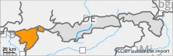
The avalanche risk is considerable above the tree line and moderate below it. The main problem at all altitudes is wind slab avalanches. Slab avalanches can be triggered in blown-in areas, especially on steep slopes with aspects from north to east to south and in gullies and bowls with little additional load. Avalanche prone locations can also be found in forest transition areas as well as in forest aisles and clearings. Avalanches reach medium size.
Soft new fallen snow continues to be problematic. Loose snow avalanches release themselves from the rocky steep terrain or can be triggered by a single skier on very steep slopes. The first naturally triggered avalanches are to be expected in the afternoon, especially in the forest area.
Snowpack
In the leeward areas of the eastern aspects and in gullies, bowls and gaps in the forest, there are sometimes thick drift snow packs that continue to grow with the onset of wind from south-westerly directions. They are widely lying on soft layers or surface hoar and are interspersed with weak intermediate layers. In the afternoon, the snowfall will change to rain at medium altitudes. At higher altitudes, the snowpack base often consists of faceted crystals.
Tendency
The risk of avalanches will decrease over the next few days with warmer temperatures.