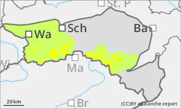
The avalanche risk is moderate above the tree line. Fresh drift snow areas can be triggered as small to medium-sized slab avalanches by low additional loads. The avalanche prone locations are located in particular in the steep terrain adjacent to the ridgeline, crest or summit in the north, east and south aspects as well as in gullies and bowls.
Snowpack
Since Thursday, 15 to 30 cm of new fallen snow has fallen, which was deposited with strong winds from the west as wind slab snow on a soft layer of snow interspersed with graupel. New fallen snow and wind create fresh drift snow areas. Weak layers for slab avalanches form soft deposits within the fresh, bound snow layer as well as soft snow layers (new fallen snow, faceted crystals) in the transition to the crusted can form. In places, their foundations are additionally weakened by kinetic metamorphism. In general, the amount of snow is still well below average.
Tendency
After a sunny start on Monday, it will become increasingly cloudy from the west, with light snowfall in the afternoon. With moderate westerly winds, it will become much milder at all altitudes. Wind slabs remain the main problem at higher altitudes!
Danger level
treeline
Avalanche Problem
Wind slab
Treeline
Snowdrift accumulations are prone to triggering in places!
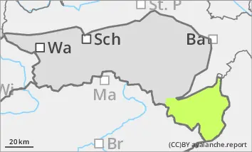
The avalanche danger is low. Nevertheless, fresh drift snow areas can be triggered as small slab avalanches by a single person. The avalanche prone locations are located in particular in the steep terrain adjacent to the ridgeline, crest or summit in the north-west, east to south aspects as well as in gullies and bowls. The risk of being swept away and falling continues to outweigh the risk of burial.
Snowpack
Some new fallen snow was deposited by strong winds from westerly directions in the leeward areas as wind slab on a soft layer of snow interspersed with graupel. A little rain and warming has partially moistened the snow cover, where a melt-freeze crust has formed. Weak layers for slab avalanches form soft snow layers (new fallen snow, faceted crystals) in the transition to the crusted old snowpack, the foundation of which is occasionally weakened by kinetic metamorphism. The snow depth varies greatly. Hardness, blown and drifting snow-laden areas alternate.
Tendency
After a sunny start on Monday, it will become increasingly cloudy from the west, with light snowfall in the afternoon. With a moderate westerly wind, it will become much milder at all altitudes. Wind slabs at higher altitudes will remain the main problem for the time being.
Danger level
Note isolated snowdrift accumulations
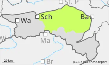
The avalanche danger is low. There are only a few fresh snowdrift accumulations in gullies and bowls and behind exposed broad ridges and ridgelines. These can be triggered as small slab avalanches. The risk of falling outweighs the risk of burial.
Snowpack
At higher altitudes, fresh snowdrift accumulations often lie on soft layers of snow, which can act as a weak layer. In addition, some rain and brief warming has partially moistened the snow cover, where a melt-freeze crust has formed with renewed cooling. In general, there is little snow.
Tendency
After a sunny start on Monday, it will become increasingly cloudy from the west, with light snowfall in the afternoon. With moderate westerly winds, it will become much milder at all altitudes. Little change in the avalanche risk.