The danger of Avalanche is low. Be careful in fresh Snowdrift accumulations!
The snowpack is mostly stable. In some places in the high alpine regions, especially on fresh drifts of blown snow, a small, clustered avalanche can be triggered under higher loads.
Snowpack
dp.4: cold following warm / warm following cold
There is little snow, and the peaks and ridges are in some places blown bare. During the last deterioration, about 10 cm of New fallen snow fell, on Sunny slope below 2000 m on terrestrial ground.
In the high alpine regions, weak layers may be present in the old snow cover.
On prominent ones, the snow has already been frozen off and then frozen over, forming a drift.
Tendency
Thursday will be mostly sunny with some transparent high clouds. SW winds will pick up in the evening, but it will remain cool.
Friday will be cloudy. The weekend will be cloudy and foggy, windy and snowy.
Danger level
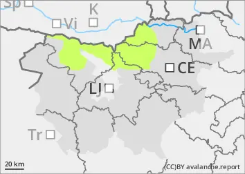
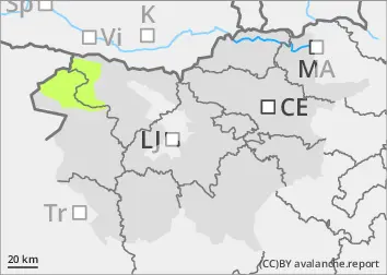
2000m
Avalanche Problem
Persistent weak layer
2000m
Wind slab
Treeline
The danger of Avalanche is low. Be careful in fresh snowdrift accumulations!
Snowpack is mostly stable. In some places in the High alpine regions, especially on fresh snowdrift accumulations of blown snow, a small, clustered avalanche can be triggered under higher loads.
Snowpack
dp.4: cold following warm / warm following cold
There is little snow, and the peaks and ridges are in some places blown bare. During the last deterioration, about 10 cm of New fallen snow fell, on Sunny slope below 2000 m on terrestrial ground.
In the high alpine regions, weak layers may be present in the old snow cover.
On prominent ones, the snow has already been frozen off and then frozen over, forming a drift.
Tendency
Thursday will be mostly sunny with some transparent high clouds. In the afternoon, low clouds will thicken on the coastal side of the Alps and lift towards the Ridge. SW winds will pick up in the evening, but it will remain cool.
Friday will be cloudy, with occasional showers.
The weekend will be cloudy and foggy, windy and snowy.